In accordance with SO #3423 - The Gulf of America and SO #3424 - Mount McKinley and Landmarks Honoring the Alaskan People, new USGS data releases specific to those named places will utilize the new name Gulf of America and the restored name Mount McKinley. Per USGS practice, historical data will retain the name of the geographic features as they were known at the time the data were originally released.
Data Release
EAARL-B Submerged Topography—Saint Croix, U.S. Virgin Islands, 2014
By Xan Fredericks, Christine J. Kranenburg, and David B. Nagle
USGS, St. Petersburg, Florida
Summary
These datasets, prepared by the U.S. Geological Survey St. Petersburg Coastal and Marine Science Center, provide lidar-derived submerged topography for a portion of the submerged environs of Saint Croix, U.S. Virgin Islands. Elevation measurements were acquired by the second-generation Experimental Advanced Airborne Research Lidar (EAARL-B) on March 11, 19, and 21, 2014, in cooperation with the National Oceanic and Atmospheric Administration Coral Reef Conservation Program.
Data
| File Name and Description | Metadata (XML format) | Metadata (text format) | Download |
|---|---|---|---|
| STCR2014_EAARLB_v09g12B_mosaic.zip Lidar-derived submerged topography for a portion of the submerged environs of Saint Croix, U.S. Virgin Islands (.tif) |
STCR2014_EAARLB_v09g12B_ mosaic_metadata.xml |
STCR2014_EAARLB_v09g12B_ mosaic_metadata.txt |
STCR2014_EAARLB_v09g12B_ mosaic.zip (30 MB) |
| STCR2014_EAARLB_v09g12B.zip Lidar-derived submerged topography point cloud for a portion of the submerged environs of Saint Croix, U.S. Virgin Islands (.xyz) |
STCR2014_EAARLB_v09g12B_ metadata.xml |
STCR2014_EAARLB_v09g12B_ metadata.txt |
STCR2014_EAARLB_v09g12B.zip (237 MB) |
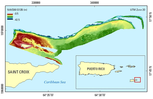
Figure 1. EAARL-B submerged topography extent for Saint Croix, U.S. Virgin Islands; data were collected March 11, 19, and 21, 2014.
Suggested Citation
Fredericks, Xan, Kranenburg, C.J., and Nagle, D.B., 2015, EAARL-B Submerged Topography—Saint Croix, U.S. Virgin Islands, 2014: U.S. Geological Survey data release, https://doi.org/10.5066/F73T9F86.