In accordance with SO #3423 - The Gulf of America and SO #3424 - Mount McKinley and Landmarks Honoring the Alaskan People, new USGS data releases specific to those named places will utilize the new name Gulf of America and the restored name Mount McKinley. Per USGS practice, historical data will retain the name of the geographic features as they were known at the time the data were originally released.
Data Release
Historical Shoreline for New Jersey (1839 to 1875): T-sheets and Vector Digital Data
By Joseph F. Terrano and Kathryn E.L. Smith
USGS, St. Petersburg, Florida
Summary
Historical shoreline surveys were conducted by the National Ocean Service (NOS), dating back to the early 1800s. The maps resulting from these surveys, often called t-sheets, provide a reference of historical shoreline position that can be compared to modern data to identify shoreline change. The t-sheets are stored at the National Archives and many have been scanned by the National Oceanic and Atmospheric Administration (NOAA) and are available on the NOAA Shoreline website (https://shoreline.noaa.gov/data/datasheets/t-sheets.html). While some scanned t-sheets were georeferenced and digitized by NOAA, others remain as non-georeferenced raster files (https://nosimagery.noaa.gov/images/shoreline_surveys/survey_scans/NOAA_Shoreline_Survey_Scans.html).
This data set features georeferenced t-sheets and digitized historic shoreline for the New Jersey coastline from 1839 to 1875. The data were scanned by NOAA, but were not georeferenced. The t-sheets included in this data release are: T-121 (1839), T-119 Part 1 (1841), T-1084 (1868), T-1166 (1870), T-1333 (1871), T-1315a (1872), T-1371 (1874), T-1407 (1875). Digital files were georeferenced, corrected to a modern datum, and shorelines digitized to provide a vector polyline depicting the historical shoreline position. All shorelines, including the foreshore, backshore, mainland and island shorelines were delineated and digitized for each survey using ArcMap 10.3.1. This data release includes 8 raster t-sheets and 1 vector shoreline. These shorelines were digitized for use in long-term shoreline and wetland analyses for Hurricane Sandy wetland physical change assessment.
Data
| File Name and Description | Metadata (XML format) | Metadata (text format) | Download File |
|---|---|---|---|
| New_Jersey_1839_75_t-sheets.zip Georeferenced scans of t-sheets, dating from 1839 to 1875. There are 8 t-sheets, one for each available date to make a continuous shoreline (.tif) |
New_Jersey_1839_75_ T-sheet_Metadata.xml |
New_Jersey_1839_75_ T-sheet_Metadata.txt |
New_Jersey_1839_75_T-sheets.zip (179.9 MB) |
| New_Jersey_1839_75_Shoreline.zip Line shapefile of shorelines derived from NOAA t-sheets to cover the New Jersey study area (.shp) |
New_Jersey_1839_75_ Shoreline_Metadata.xml |
New_Jersey_1839_75_ Shoreline_Metadata.txt |
New_Jersey_1839_75_Shoreline.zip
(709 KB) |
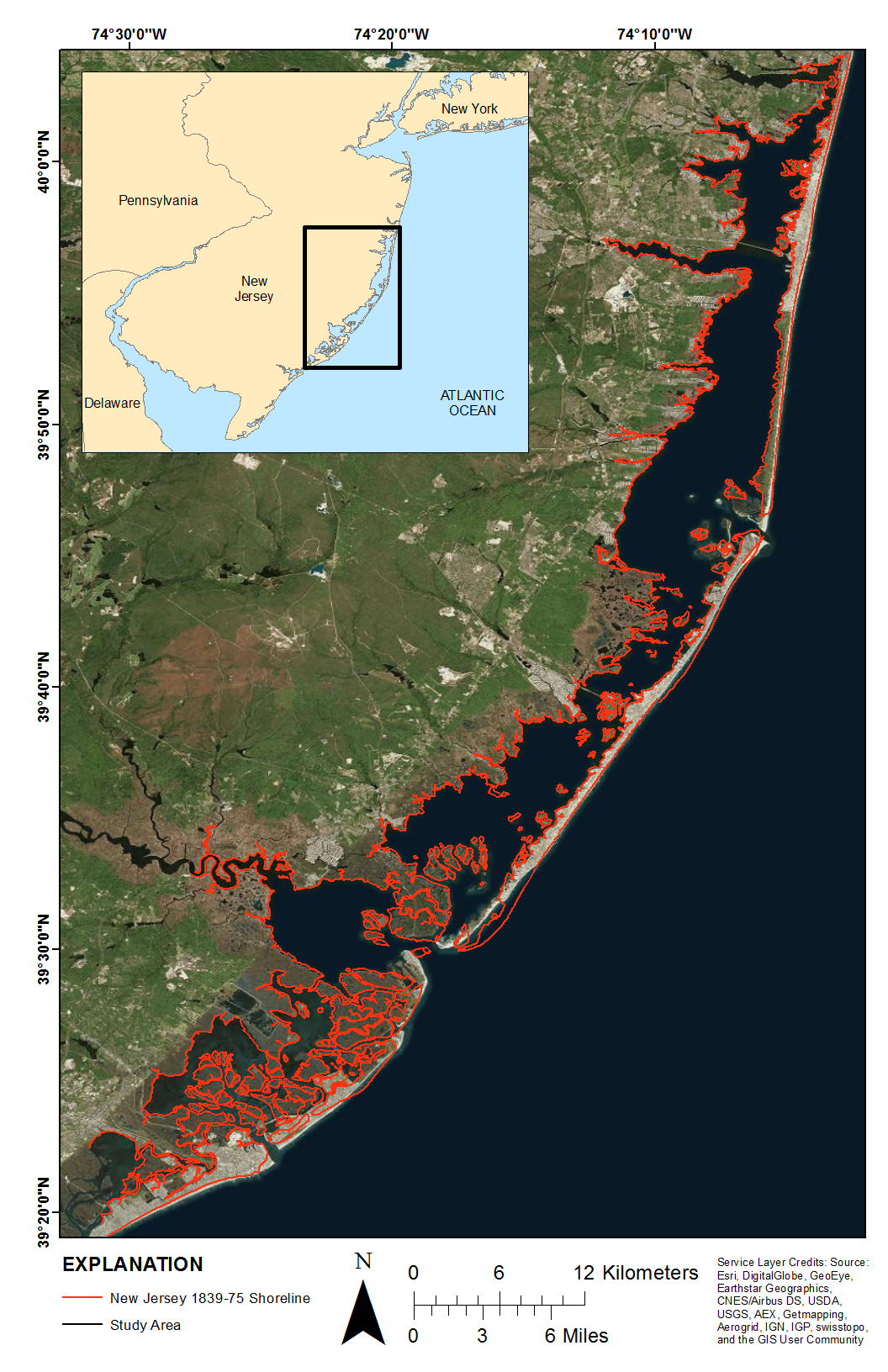
Figure 1. Map showing the study area in New Jersey and the shoreline digitized from t-sheets.
Suggested Citation
Terrano, J.F., and Smith, K.E.L., 2016, Historical Shoreline for New Jersey (1839 to 1875), T-sheets and Vector Digital Data: U.S. Geological Survey data release, https://doi.org/10.5066/F7KH0KFX