In accordance with SO #3423 - The Gulf of America and SO #3424 - Mount McKinley and Landmarks Honoring the Alaskan People, new USGS data releases specific to those named places will utilize the new name Gulf of America and the restored name Mount McKinley. Per USGS practice, historical data will retain the name of the geographic features as they were known at the time the data were originally released.
Data Release
A GIS Compilation of Vector Shorelines and Associated Shoreline Change Data for Breton Island, Louisiana: 1869-2014
By Joseph F. Terrano, James G. Flocks, and Kathryn E.L. Smith
USGS, St. Petersburg, Florida
Summary
Many barrier islands in the United States are experiencing substantive erosion and elevation loss due to storm surge, waves, and sea-level changes; this is particularly true for the deltaic barrier system in Louisiana. Breton Island is located near the mouth of the Mississippi River in the southern end of the Chandeleur Island chain in southeast Louisiana. This report expands on previous geomorphic studies of Breton Island by incorporating additional historic and recent datasets. Multiple analyses focused on long- and short-term shoreline change, as well as episodic events and anthropogenic modification. Analyses time periods included the long-term (1869–2014), long-term historic (1869–1950), post Mississippi River Gulf Outlet (1950–2014), pre/post Hurricane Katrina (2004–2005), and recent (2005–2014) change. In addition to shoreline change, barrier island geomorphology was evaluated using island area, elevation, and sediment volume change. In the long term (1969–2014), Breton Island has experienced landward transgression, island narrowing, and elevation loss. Major storm events are exacerbating the long-term trends. However, the short-term trends (2005–2014) show that Breton Island is eroding at a slower rate than long-term and has gained area and total sediment volume. The short-term accretion is likely due to the lack of major storms since Hurricane Katrina (2005).
Data
| File Name and Description | Metadata (XML format) |
Metadata (text format) | Download |
|---|---|---|---|
| baseline.zip A line shapefile parallel to, and seaward of, the Breton Island 1869-2014 shorelines. The baseline serves as a starting point for the Digital Shoreline Analysis System (DSAS) to cast transects. | baseline-metadata.xml | baseline-metadata.txt | baseline.zip (17 KB) |
| shorelines.zip Line shapefiles of mean high water shorelines derived from NOAA T-Sheets, aerial imagery, and Lidar, for Breton Island, LA, dating from 1869 to 2014. There are 14 shapefiles, one for each available date. | shoreline-metadata-xml.zip | shoreline-metadata-txt.zip | shorelines.zip (968 KB) |
| transects.zip Line shapefiles of transects generated from the DSAS rate of change program. Transects were generated for the analysis time periods: long-term (1869–2014), long-term historic (1869–1950), post Mississippi River-Gulf Outlet (1950–2014), pre/post Hurricane Katrina (2004–2005), and recent (2005–2014). Rate of change statistics from each analysis are joined to the corresponding transects. There are 5 shapefiles, one for time period. | transect-metadata-xml.zip | transect-metadata-txt.zip | transects.zip (139 KB) |
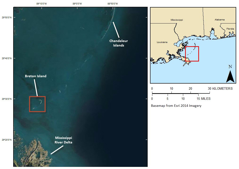
Figure 1. Location map.
Suggested Citation
Terrano, J.F., Flocks, J.G., and Smith, K.E.L., 2015, A GIS compilation of vector shorelines and associated shoreline change data for Breton Island, Louisiana: 1869–2014: U.S. Geological Survey data release, https://doi.org/10.5066/F7XS5SGM.