In accordance with SO #3423 - The Gulf of America and SO #3424 - Mount McKinley and Landmarks Honoring the Alaskan People, new USGS data releases specific to those named places will utilize the new name Gulf of America and the restored name Mount McKinley. Per USGS practice, historical data will retain the name of the geographic features as they were known at the time the data were originally released.
Data Release
EAARL Coastal Topography—Texas, Post-Hurricane Ike, 2008
By Matthew W. Hardy, Christine J. Kranenburg, and Kara S. Doran
USGS, St. Petersburg, Florida
Summary
These datasets, prepared by the U.S. Geological Survey St. Petersburg Coastal and Marine Science Center, provide lidar-derived first-surface and bare-earth topography for a portion of the Texas coastline. Elevation measurements were acquired by the Experimental Advanced Airborne Research Lidar (EAARL) on September 17th, 2008, following Hurricane Ike landfall.
Data
| File Name and Description | Metadata (XML format) | Metadata (text format) | Download File |
|---|---|---|---|
| IKE2008_Texas_EAARLA_FS_n88g96.zip Lidar-derived first-surface topography collected post-Hurricane Ike in Texas (.xyz) |
IKE2008_Texas_EAARLA_FS _n88g96_metadata.xml |
IKE2008_Texas_EAARLA_FS _n88g96_metadata.txt |
IKE2008_Texas_EAARLA_FS _n88g96.zip |
| IKE2008_Texas_EAARLA_BE_n88g96.zip Lidar-derived bare-earth topography collected post-Hurricane Ike in Texas (.xyz) |
IKE2008_Texas_EAARLA_BE _n88g96_metadata.xml |
IKE2008_Texas_EAARLA_BE _n88g96_metadata.txt |
IKE2008_Texas_EAARLA_BE _n88g96.zip |
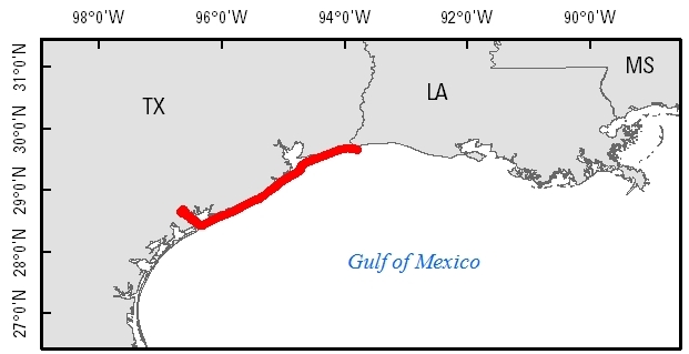
Figure 1. EAARL first-surface and bare-earth topography extent for Texas; data were collected post-Hurricane Ike, in September 2008.
Suggested Citation
Hardy, M.W., Kranenburg, C.J., Doran, K.S., 2017, EAARL Coastal Topography—Texas, Post-Hurricane Ike, 2008: U.S. Geological Survey data release, https://doi.org/10.5066/F74X56N2.