In accordance with SO #3423 - The Gulf of America and SO #3424 - Mount McKinley and Landmarks Honoring the Alaskan People, new USGS data releases specific to those named places will utilize the new name Gulf of America and the restored name Mount McKinley. Per USGS practice, historical data will retain the name of the geographic features as they were known at the time the data were originally released.
Data Release
Archive of Digitized Analog Boomer Seismic Reflection Data Collected During U.S. Geological Survey Cruise Acadiana 87-2 in the Northern Gulf of Mexico, June 1987
By Stephen T. Bosse, James G. Flocks, and Arnell S. Forde
USGS, St. Petersburg, Florida
Summary
The U.S. Geological Survey (USGS) Coastal and Marine Geology Program has actively collected geophysical and sedimentological data in the northern Gulf of Mexico for several decades, including shallow subsurface data in the form of high-resolution seismic reflection profiles (HRSP). Prior to the mid-1990s most HRSP data were collected in analog format as paper rolls of continuous profiles up to 25 meters long. As part of the National Geological and Geophysical Data Preservation Program, scientists at the USGS St. Petersburg Coastal and Marine Science Center are converting the analog paper records to digital format using a large-format continuous scanner.
This data release serves as an archive of seismic profiles with headers, converted Society of Exploration Geophysicists (SEG-Y) files, navigation data, and trackline shapefiles for digitized boomer seismic data collected from the Research Vessel (R/V) Acadiana. The Acadiana 87-2 geophysical cruise included seismic data collected in the northern Gulf of Mexico, Chandeleur Sound, and Mississippi Sound from June 15–26, 1987. Data collection and processing methods are described in USGS Data Series 1047.
Bosse, S.T., Flocks, J.G., and Forde, A.S., 2017, Digitized analog boomer seismic-reflection data collected during U.S. Geological Survey cruises Erda 90-1_HC, Erda 90-1_PBP, and Erda 91-3 in Mississippi Sound, June 1990 and September 1991: U.S. Geological Survey Data Series 1047, https://doi.org/10.3133/ds1047.
Data
| File Name and Description | Metadata (XML format) | Metadata (text format) | Download File |
|---|---|---|---|
| Acadiana 87-2 | |||
| Profileswithheaders_A87-2.zip Printable seismic profiles with headers (.tif). |
Acadiana_Metadata.xml | Acadiana_Metadata.txt | Profileswithheaders_A87-2.zip (5.5 GB) |
| ProfilesWithScales_A87-2.zip Processed seismic profile images with axis scales and headers (.pdf) |
Same as above | Same as above | ProfilesWithScales_A87-2.zip (1.4 GB) |
| SEGY_A87-2.zip Digitally-converted seismic profiles, in SEG-Y format (.seg). |
Same as above | Same as above | SEGY_A87-2.zip (2.8 GB) |
| Navigation_A87-2.zip Long range navigation (LORAN) system geographic position data (.txt). |
Same as above | Same as above | Navigation_A87-2.zip (23 KB) |
| CruiseTracklines_A87-2.zip Cruise trackline location shapefile (.shp). |
Same as above | Same as above | CruiseTracklines_A87-2.zip (31 KB) |
| Supplemental Information | |||
| Logbook_A87-2.zip | Not applicable | Not applicable | Logbook_A87-2.zip (2.8 MB) |
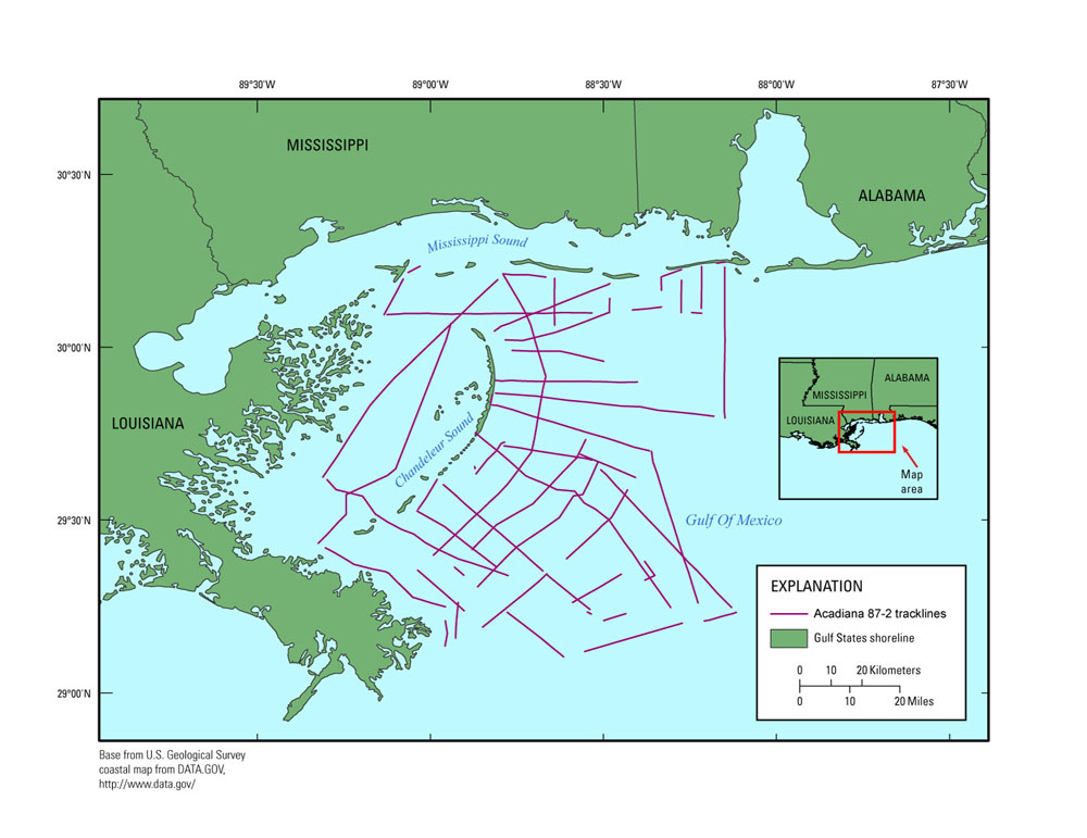
Figure 1. Map of cruise tracklines from the Acadiana 87-2 survey.
Suggested Citation
Bosse, S.T., Flocks, J.G., and Forde, A.S., 2017, Archive of digitized analog boomer seismic reflection data collected during U.S. Geological Survey cruise Acadiana 87-2 in the northern Gulf of Mexico, June 1987: U.S Geological Survey data release, https://doi.org/10.5066/F7F47MC2.