In accordance with SO #3423 - The Gulf of America and SO #3424 - Mount McKinley and Landmarks Honoring the Alaskan People, new USGS data releases specific to those named places will utilize the new name Gulf of America and the restored name Mount McKinley. Per USGS practice, historical data will retain the name of the geographic features as they were known at the time the data were originally released.
Data Release
Coastal Topography—Anegada, British Virgin Islands, 2014
By Xan Fredericks, Uri S. ten Brink, Brian F. Atwater, Christine J. Kranenburg, and David B. Nagle
USGS, St. Petersburg, Florida
Summary
These datasets provide lidar-derived topography for Anegada and a portion of the submerged environs. Elevation measurements were acquired on January 21, 2014 by an Optech Orion M300, and on March 19-20, 2014 by the second-generation Experimental Advanced Airborne Research Lidar (EAARL-B).
The authors acknowledge Emily Klipp, Chris Pali, Virgil Rabine, Rudy Troche, and Wayne Wright, all formerly of the USGS; Sharlene DaBreo, Jason Penn, and Christopher Williams of the Department of Disaster Management, British Virgin Islands; Alberto López of the University of Puerto Rico, Mayagüez; and Brian Andrews, Verita Friesner, and Craig Weaver of the USGS for their extensive logistical efforts, coordination contributions, and data support.
Data
| File Name and Description | Metadata (XML format) | Metadata (text format) | Download File |
|---|---|---|---|
| ANGD2014_BE_z20_n88g12A_mosaic.zip Lidar-derived bare-earth topography Digital Elevation Model (DEM) mosaic for Anegada, British Virgin Islands (.tif) |
ANGD2014_BE_z20_n88g12A_ mosaic_metadata.xml |
ANGD2014_BE_z20_n88g12A_ mosaic_metadata.txt |
ANGD2014_BE_z20_n88g12A_ mosaic.zip (59 MB) |
| ANGD2014_EAARLB_z20_v09g12A_mosaic.zip Lidar-derived seamless (bare earth and submerged) topography DEM mosaic for a portion of the environs of Anegada, British Virgin Islands (.tif) |
ANGD2014_EAARLB_z20_v09g12A_ mosaic_metadata.xml |
ANGD2014_EAARLB_z20_v09g12A_ mosaic_metadata.txt |
ANGD2014_EAARLB_z20_v09g12A_ mosaic.zip (76.4 MB) |
| ANGD2014_EAARLB_z20_v09g12A.zip Lidar-derived seamless (bare earth and submerged) topography point cloud for a portion of the environs of Anegada, British Virgin Islands (.xyz) |
ANGD2014_EAARLB_z20_v09g12A_ metadata.xml |
ANGD2014_EAARLB_z20_v09g12A_ metadata.txt |
ANGD2014_EAARLB_z20_v09g12A.zip (480 MB) |
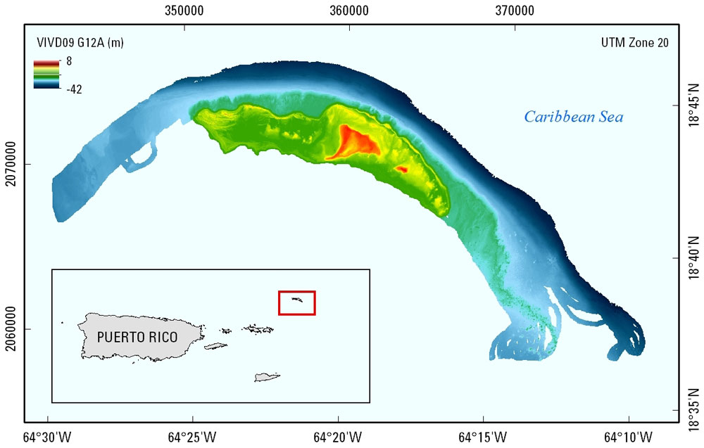
Figure 1. Lidar-derived topography extent for Anegada, British Virgin Islands; data were collected in January and March, 2014.
Suggested Citation
Fredericks, X., ten Brink, U.S., Atwater, B.F., Kranenburg, C.J., and Nagle, D.B., 2016, Coastal Topography—Anegada, British Virgin Islands, 2014: U.S. Geological Survey data release, https://doi.org/10.5066/F7GM85F3.