In accordance with SO #3423 - The Gulf of America and SO #3424 - Mount McKinley and Landmarks Honoring the Alaskan People, new USGS data releases specific to those named places will utilize the new name Gulf of America and the restored name Mount McKinley. Per USGS practice, historical data will retain the name of the geographic features as they were known at the time the data were originally released.
Data Release
Dauphin Island Storms and Sea Level Rise Assessment: XBeach Model Inputs and Results
By Davina L. Passeri,1 Matthew V. Bilskie,2 Nathaniel G. Plant,1 Joseph W. Long,1 and Scott C. Hagen2
1U.S. Geological Survey, St. Petersburg Coastal and Marine Science Center, St. Petersburg, FL, USA
2Louisiana State University, Department of Civil & Environmental Engineering/Center for Computation and Technology, Baton Rouge, LA, USA
Summary
XBeach was used to simulate hurricanes Ivan (2004) and Katrina (2005) at Dauphin Island, Alabama, under present-day conditions and future sea level rise (SLR) scenarios as described in Passeri and others, 2018. Model inputs and outputs in the form of topography and bathymetry are provided here. For further information regarding model input generation and visualization of model output topography and bathymetry, refer to Passeri and others, 2018.
Passeri, D.L., Bilskie, M.V., Plant, N.G., Long, J.W., and Hagen, S.C., 2018, Dynamic modeling of barrier island response to hurricane storm surge under future sea level rise: Climatic Change, https://doi.org/10.1007/s10584-018-2245-8.
Data
| File Name and Description | Metadata (XML format) | Metadata (text format) | Download File |
|---|---|---|---|
| Initial_Elevations.zip NetCDF file containing the following variables: coordinates of the model grid (Easting and Northing); the initial bathymetry/topography (z) model grid (.nc) |
Initial_Elevations_metadata.xml | Initial_Elevations_metadata.txt | Initial_Elevations.zip (14.9 MB) |
| Ivan_Present_Day.zip NetCDF file containing the following variables: coordinates of the model grid (Easting and Northing); the final bathymetry/topography (z) for the Ivan present-day scenario (.nc) |
Ivan_Present_Day_metadata.xml | Ivan_Present_Day_metadata.txt | Ivan_Present_Day.zip (21.8 MB) |
| Ivan_Low_SLR.zip NetCDF file containing the following variables: coordinates of the model grid (Easting and Northing); the final bathymetry/topography (z) for the Ivan low sea level rise (SLR) scenario (.nc) |
Ivan_Low_SLR_metadata.xml | Ivan_Low_SLR_metadata.txt | Ivan_Low_SLR.zip (21.9 MB) |
| Ivan_IntLow_SLR.zip NetCDF file containing the following variables: coordinates of the model grid (Easting and Northing); the final bathymetry/topography (z) for the Ivan intermediate-low sea level rise (SLR) scenario (.nc) |
Ivan_IntLow_SLR_metadata.xml | Ivan_IntLow_SLR_metadata.txt | Ivan_IntLow_SLR.zip (21.9 MB) |
| Ivan_Static_Low_SLR.zip NetCDF file containing the following variables: coordinates of the model grid (Easting and Northing); the final bathymetry/topography (z) for the Ivan static low sea level rise (SLR) scenario (.nc) |
Ivan_Static_Low_SLR_metadata.xml | Ivan_Static_Low_SLR_metadata.txt | Ivan_Static_Low_SLR.zip (21.8 MB) |
| Ivan_Static_IntLow_SLR.zip NetCDF file containing the following variables: coordinates of the model grid (Easting and Northing); the final bathymetry/topography (z) for the Ivan static intermediate-low sea level rise (SLR) scenario (.nc) |
Ivan_Static_IntLow_SLR_metadata.xml | Ivan_Static_IntLow_SLR_metadata.txt | Ivan_Static_IntLow_SLR.zip (21.8 MB) |
| Katrina_Present_Day.zip NetCDF file containing the following variables: coordinates of the model grid (Easting and Northing); the final bathymetry/topography (z) for the Katrina present-day scenario (.nc) |
Katrina_Present_Day_metadata.xml | Katrina_Present_Day_metadata.txt | Katrina_Present_Day.zip (21.9 MB) |
| Katrina_Low_SLR.zip NetCDF file containing the following variables: coordinates of the model grid (Easting and Northing); the final bathymetry/topography (z) for the Katrina low sea level rise (SLR) scenario (.nc) |
Katrina_Low_SLR_metadata.xml | Katrina_Low_SLR_metadata.txt | Katrina_Low_SLR.zip (21.9 MB) |
| Katrina_IntLow_SLR.zip NetCDF file containing the following variables: coordinates of the model grid (Easting and Northing); the final bathymetry/topography (z) for the Katrina intermediate-low sea level rise (SLR) scenario (.nc) |
Katrina_IntLow_SLR_metadata.xml | Katrina_IntLow_SLR_metadata.txt | Katrina_IntLow_SLR.zip (21.9 MB) |
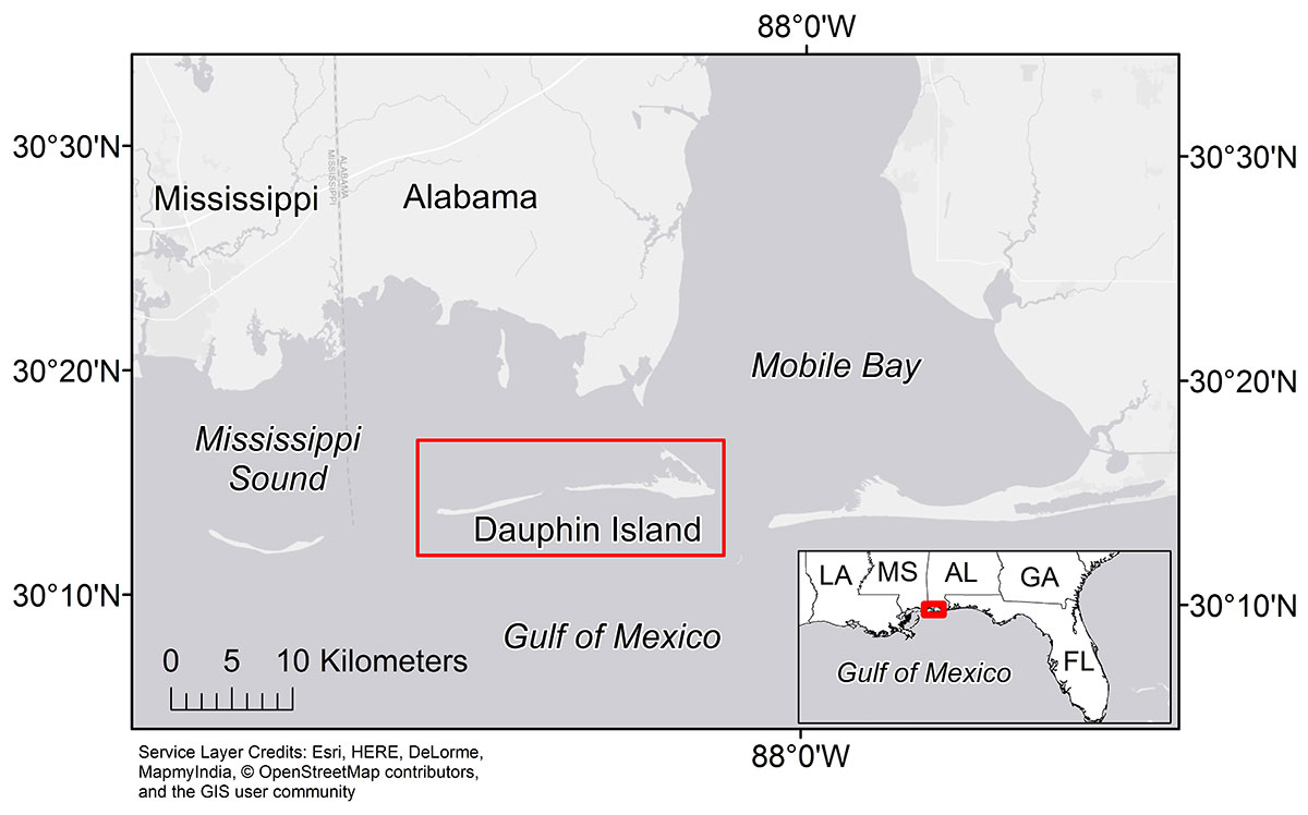
Figure 1. Dauphin Island, Alabama, is located off the Alabama coast between the Mississippi Sound and the Gulf of Mexico.
Suggested Citation
Passeri, D.L., Bilskie, M.V., Plant, N.G., Long, J.W., and Hagen, S.C., 2018, Dauphin Island XBeach sea level rise assessment—model inputs and results: U.S. Geological Survey data release, https://doi.org/10.5066/F7N87930.