In accordance with SO #3423 - The Gulf of America and SO #3424 - Mount McKinley and Landmarks Honoring the Alaskan People, new USGS data releases specific to those named places will utilize the new name Gulf of America and the restored name Mount McKinley. Per USGS practice, historical data will retain the name of the geographic features as they were known at the time the data were originally released.
Data Release
Coastal Topography—Assateague Island, Maryland and Virginia, Post-Hurricane Hermine, 10–12 September 2016
By Xan Fredericks and Nathaniel G. Plant
USGS, St. Petersburg, Florida
Summary
Lidar-derived seamless (bare earth and submerged) topography Digital Elevation Model (DEM) mosaic and classified point-cloud datasets were produced from remotely sensed, geographically referenced elevation measurements collected post-Hurricane Hermine on September 10–12, 2016.
Data
| File Name and Description | Metadata (XML format) | Metadata (text format) | Download File |
|---|---|---|---|
| ASIS2016_HRHM_SM_z18_n88g12B_mosaic.zip Lidar-derived seamless topography DEM mosaic for Assateague Island, Maryland and Virginia, collected post-Hurricane Hermine (.tif) |
ASIS2016_HRHM_SM_z18_n88g12B _mosaic_metadata.xml |
ASIS2016_HRHM_SM_z18_n88g12B _mosaic_metadata.txt |
ASIS2016_HRHM_SM_z18_n88g12B _mosaic.zip (203 MB) |
| ASIS2016_HRHM_SM_z18_n88g12B_classified.zip Lidar-derived classified point-cloud dataset for Assateague Island, Maryland and Virginia, collected post-Hurricane Hermine. Please note large file size impacts load rate (.laz) |
ASIS2016_HRHM_SM_z18_n88g12B _classified_metadata.xml |
ASIS2016_HRHM_SM_z18_n88g12B _classified_metadata.txt |
ASIS2016_HRHM_SM_z18_n88g12B _classified.zip (17.6 GB) |
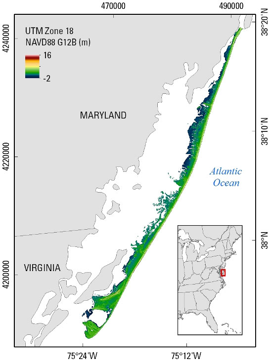
Figure 1. Seamless (bare earth and submerged) topography DEM extent on Assateague Island, Maryland and Virginia; data were collected post-Hurricane Hermine on September 10–12, 2016.
Suggested Citation
Fredericks, Xan, and Plant, N.G., 2017, Coastal Topography—Assateague Island, Maryland and Virginia, Post-Hurricane Hermine, 10–12 September 2016: U.S. Geological Survey data release, https://doi.org/10.5066/F7NP22NH.