In accordance with SO #3423 - The Gulf of America and SO #3424 - Mount McKinley and Landmarks Honoring the Alaskan People, new USGS data releases specific to those named places will utilize the new name Gulf of America and the restored name Mount McKinley. Per USGS practice, historical data will retain the name of the geographic features as they were known at the time the data were originally released.
Data Release
Archive of Digitized Analog Boomer Seismic Reflection Data Collected Along the Louisiana Shelf, 1982–1984
By Stephen T. Bosse, James G. Flocks, and Arnell S. Forde
USGS, St. Petersburg, Florida
Summary
The U.S. Geological Survey (USGS) Coastal and Marine Geology Program has actively collected geophysical and sedimentological data in the northern Gulf of Mexico for several decades, including shallow subsurface data in the form of high-resolution seismic reflection profiles (HRSP). Prior to the mid-1990s most HRSP data were collected in analog format as paper rolls of continuous profiles up to 25 meters long. As part of the National Geological and Geophysical Data Preservation Program, and in collaboration with the Bureau of Ocean Energy Management, Marine Minerals Program, scientists at the USGS St. Petersburg Coastal and Marine Science Center are converting the analog paper records to digital format using a large-format continuous scanner. The scanned images were further processed to fix distortions and crop out blank spaces prior to creating industry standard Society of Exploration Geophysicists (SEG-Y) formatted files.
This data release serves as an archive of HRSP profiles annotated with header information, converted SEG-Y files, navigation data, and cruise trackline shapefiles. The HRSP data were collected using a Huntec boomer seismic system onboard the Research Vessels (R/V) R.J. Russell and Carancahua. While on the R/V R.J. Russell, geophysical surveys were conducted at various times between December 1982 and July 1984 with the data being acquired from waterbodies surrounding Isles Dernieres (Lacoss 82-2, 83-3 and 83-4), within Terrebonne and Caillou Bay (82-2), and offshore of Port Fourchon, Louisiana (84-5). While on the R/V Carancahua, geophysical surveys were collected between August and September 1982 off the coast of Holly Beach, Louisiana (82-3). Data collection and processing methods are described in USGS Data Series 1047.
References
Bosse, S.T., Flocks, J.G., and Forde, A.S., 2017, Digitized analog boomer seismic-reflection data collected during U.S. Geological Survey cruises Erda 90-1_HC, Erda 90-1_PBP, and Erda 91-3 in Mississippi Sound, June 1990 and September 1991: U.S. Geological Survey Data Series 1047, https://doi.org/10.3133/ds1047.
Data
| File Name and Description | Metadata (XML format) | Metadata (text format) | Download File |
|---|---|---|---|
| Lacoss 82-2 | |||
| Lacoss82-2_ProfilesWithHeaders.zip Printable seismic profiles with headers containing cruise, line, and scanning information (.tif) |
Lacoss_metadata.xml | Lacoss_metadata.txt | Lacoss82-2_ProfilesWithHeaders.zip (2.7 GB) |
| Lacoss82-2_ProfilesWithScales.zip Processed seismic profile images with axis scales and headers (.pdf) |
Same as above | Same as above | Lacoss82-2_ProfilesWithScales.zip (736 MB) |
| Lacoss82-2_SEGY.zip Society of Exploration Geophysicists formatted seismic data (.seg) |
Same as above | Same as above | Lacoss82-2_SEGY.zip (1.2 GB) |
| Lacoss82-2_Navigation.zip Cruise navigation data (.xls) |
Same as above | Same as above | Lacoss82-2_Navigation.zip (48.3 KB) |
| Lacoss82-2_CruiseShapefiles.zip Cruise trackline shapefiles (.shp, .kmz) |
Same as above | Same as above | Lacoss82-2_CruiseShapefiles.zip (39 KB) |
| Lacoss 82-3 | |||
| Lacoss82-3_ProfilesWithHeaders.zip Printable seismic profiles with headers containing cruise, line, and scanning information (.tif) |
Same as above | Same as above | Lacoss82-3_ProfilesWithHeaders.zip (1.3 GB) |
| Lacoss82-3_ProfilesWithScales.zip Processed seismic profile images with axis scales and headers (.pdf) |
Same as above | Same as above | Lacoss82-3_ProfilesWithScales.zip (590 MB) |
| Lacoss82-3_SEGY.zip Society of Exploration Geophysicists formatted seismic data (.seg) |
Same as above | Same as above | Lacoss82-3_SEGY.zip (824 MB) |
| Lacoss82-3_Navigation.zip Cruise navigation data (.xls) |
Same as above | Same as above | Lacoss82-3_Navigation.zip (36.7 KB) |
| Lacoss82-3_CruiseShapefiles.zip Cruise trackline shapefiles (.shp, .kmz) |
Same as above | Same as above | Lacoss82-3_CruiseShapefiles.zip (32.4 KB) |
| Lacoss 83-3 | |||
| Lacoss83-3_ProfilesWithHeaders.zip Printable seismic profiles with headers containing cruise, line, and scanning information (.tif) |
Same as above | Same as above | Lacoss83-3_ProfilesWithHeaders.zip (3.2 GB) |
| Lacoss83-3_ProfilesWithScales.zip Processed seismic profile images with axis scales and headers (.pdf) |
Same as above | Same as above | Lacoss83-3_ProfilesWithScales.zip (340 MB) |
| Lacoss83-3_SEGY.zip Society of Exploration Geophysicists formatted seismic data (.seg) |
Same as above | Same as above | Lacoss83-3_SEGY.zip (871 MB) |
| Lacoss83-3_Navigation.zip Cruise navigation data (.xls) |
Same as above | Same as above | Lacoss83-3_Navigation.zip (33.6 KB) |
| Lacoss83-3_CruiseShapefiles.zip Cruise trackline shapefiles (.shp, .kmz) |
Same as above | Same as above | Lacoss83-3_CruiseShapefiles.zip (32 KB) |
| Lacoss 83-4 | |||
| Lacoss83-4_ProfilesWithHeaders.zip Printable seismic profiles with headers containing cruise, line, and scanning information (.tif) |
Same as above | Same as above | Lacoss83-4_ProfilesWithHeaders.zip (2.0 GB) |
| Lacoss83-4_ProfilesWithScales.zip Processed seismic profile images with axis scales and headers (.pdf) |
Same as above | Same as above | Lacoss83-4_ProfilesWithScales.zip (413 MB) |
| Lacoss83-4_SEGY.zip Society of Exploration Geophysicists formatted seismic data (.seg) |
Same as above | Same as above | Lacoss83-4_SEGY.zip (1.0 GB) |
| Lacoss83-4_Navigation.zip Cruise navigation data (.xls) |
Same as above | Same as above | Lacoss83-4_Navigation.zip (32.5 KB) |
| Lacoss83-4_CruiseShapefiles.zip Cruise trackline shapefiles (.shp, .kmz) |
Same as above | Same as above | Lacoss83-4_CruiseShapefiles.zip (26.3 KB) |
| Lacoss 84-5 | |||
| Lacoss84-5_ProfilesWithHeaders.zip Printable seismic profiles with headers containing cruise, line, and scanning information (.tif) |
Same as above | Same as above | Lacoss84-5_ProfilesWithHeaders.zip (1.0 GB) |
| Lacoss84-5_ProfilesWithScales.zip Processed seismic profile images with axis scales and headers (.pdf) |
Same as above | Same as above | Lacoss84-5_ProfilesWithScales.zip (474 MB) |
| Lacoss84-5_SEGY.zip Society of Exploration Geophysicists formatted seismic data (.seg) |
Same as above | Same as above | Lacoss84-5_SEGY.zip (877 MB) |
| Lacoss84-5_Navigation.zip Cruise navigation data (.xls) |
Same as above | Same as above | Lacoss84-5_Navigation.zip (28.6 KB) |
| Lacoss84-5_CruiseShapfiles.zip Cruise trackline shapefiles (.shp, .kmz) |
Same as above | Same as above | Lacoss84-5_CruiseShapefiles.zip (30 KB) |
| Supplemental Information | |||
| Lacoss82-2_Logbooks.zip |
Not applicable | Not applicable | Lacoss82-2_Logbooks.zip (933 KB) |
| Lacoss82-3_Logbooks.zip |
Not applicable | Not applicable | Lacoss82-3_Logbooks.zip (45.7 MB) |
| Lacoss83-3_Logbooks.zip |
Not applicable | Not applicable | Lacoss83-3_Logbooks.zip (1.7 MB) |
| Lacoss83-4_Logbook.zip |
Not applicable | Not applicable | Lacoss83-4_Logbook.zip (431 KB) |
| Lacoss84-5_Logbooks.zip |
Not applicable | Not applicable | Lacoss84-5_Logbooks.zip (3.0 MB) |
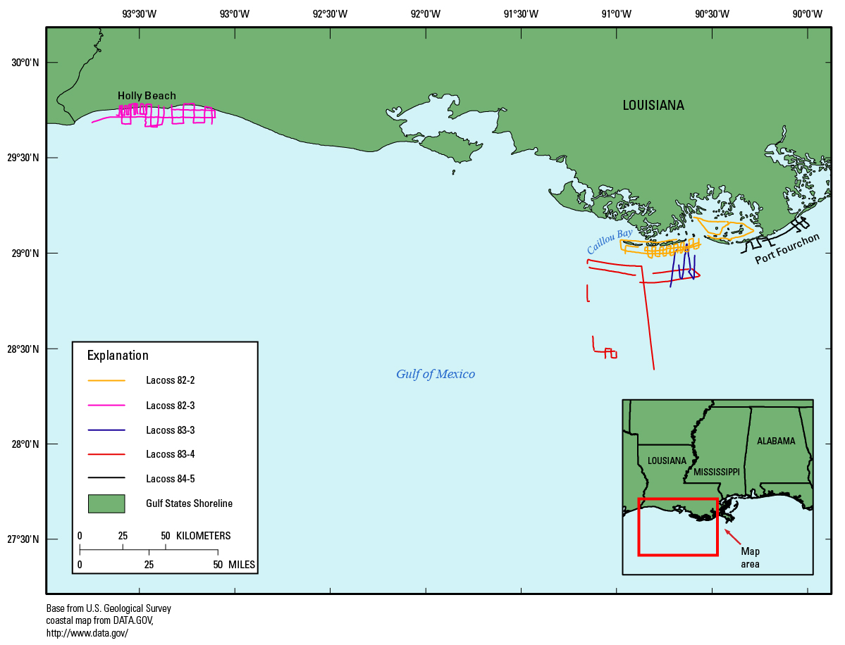
Figure 1. Map of seismic tracklines collected along the Louisiana shelf between 1982 and 1984, during the Lacoss cruises.
Suggested Citation
Bosse, S.T., Flocks, J.G., and Forde, A.S., 2018, Archive of digitized analog boomer seismic reflection data collected along the Louisiana Shelf, 1982–1984: U.S. Geological Survey data release, https://doi.org/10.5066/F7NP23H4.