In accordance with SO #3423 - The Gulf of America and SO #3424 - Mount McKinley and Landmarks Honoring the Alaskan People, new USGS data releases specific to those named places will utilize the new name Gulf of America and the restored name Mount McKinley. Per USGS practice, historical data will retain the name of the geographic features as they were known at the time the data were originally released.
Data Release
Coastal Bathymetry Data Collected in June 2018 From Fire Island, New York: Wilderness Breach and Shoreface
By Chelsea A. Stalk,1 Jennifer L. Miselis,2, 1 Timothy R. Nelson,2 Billy J. Reynolds,2 Joseph J. Fredericks,2 Nancy T. DeWitt,2 Andrew S. Farmer,1 Hunter S. Wilcox,1 and Mitchell K. Lemon2
1Cherokee Nation Technologies
2USGS SPCMSC
Summary
Scientists from the U.S. Geological Survey St. Petersburg Coastal and Marine Science Center in St. Petersburg, Florida, conducted a bathymetric survey of Fire Island, New York, from June 2 to 17, 2018. The U.S. Geological Survey is involved in a post-Hurricane Sandy effort to map and monitor the morphologic evolution of the wilderness breach and the adjacent shoreface environment. During this study, bathymetry data were collected aboard two personal watercraft (PWC) outfitted with single-beam echosounders, as well as a towed seismic sled with similar instrumentation. Additional elevation data were collected using backpack Global Positioning Systems (GPS) on flood shoals and in shallow channels within the wilderness breach. For further information regarding data collection and/or processing methods refer to USGS Data Series 1049 (https://doi.org/10.3133/ds1049), 1034 (https://doi.org/10.3133/ds1034), and 1007 (https://doi.org/10.3133/ds1007).
Data
| File Name and Description | Metadata (XML format) | Metadata (text format) | Download File |
|---|---|---|---|
| Fire_Island_2018_xyz.zip Single-beam bathymetry and GPS xyz data of both the shoreface and wilderness breach in both WGS84 (G1150) ellipsoid and NAD83 NAVD88 Geoid 12A (.txt) |
Fire_Island_2018_metadata.xml | Fire_Island_2018_metadata.txt | Fire_Island_2018_xyz.zip (189 MB) |
| Fire_Island_2018_xyz_Shapefiles.zip Single-beam bathymetry and GPS xyz data of both the shoreface and wilderness breach in both WGS84 (G1150) ellipsoid and NAD83 NAVD88 Geoid 12A (.shp) |
Same as above | Same as above | Fire_Island_2018_xyz_Shapefiles.zip (315 MB) |
| Fire_Island_2018_Tracklines.zip Single-beam bathymetry and GPS tracklines in WGS84 for both the shoreface and wilderness breach (.shp) |
Same as above | Same as above | Fire_Island_2018_Tracklines.zip (50.3 MB) |
| Fire_Island_2018_DEM.zip Two Digital Elevation Models (DEM), 100 m cell size shoreface, 25 m wilderness breach, both in NAD83 NAVD88 Geoid 12A as well as boundary shapefiles for each (.tif) (.shp) |
Same as above | Same as above | Fire_Island_2018_DEM.zip (144 KB) |
| Supplemental information | |||
| 2018-322-FA_FACS.zip Field Activity Collection System (FACS) logs (.docx) |
Not applicable | Not applicable | 2018-322-FA_FACS.zip (88 KB) |
| Fire_Island_2018_DEM_Image.zip Images of the NAD83 NAVD88 Geoid 12A DEM for both the shoreface (100 m) and wilderness breach (25 m) data (.jpg) |
Not applicable | Not applicable | Fire_Island_2018_DEM_Image.zip (509 KB) |
| Fire_Island_2018_Error_Analysis.zip Associated Root Mean Square error (RMSe) analysis values (.pdf) |
Not applicable | Not applicable | Fire_Island_2018_Error_Analysis.zip (372 KB) |
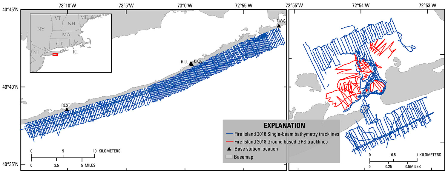
Figure 1. Trackline overview map for the 2018 Fire Island single-beam bathymetry and GPS surveys along the Island Shoreface (left) and within the Wilderness Breach (right). Base map modified from USGS 1:100,000-scale Digital Line Graph (DLG) data.
Suggested Citation
Stalk, C.A., Miselis, J.L., Nelson, T.R., Reynolds, B.J., Fredericks, J.J., DeWitt, N.T., Farmer, A.S., Wilcox, H.S., and Lemon M.K., 2018, Coastal bathymetry data collected in June 2018 from Fire Island, New York—Wilderness breach and shoreface: U.S. Geological Survey data release, https://doi.org/10.5066/F7PC30N8.