In accordance with SO #3423 - The Gulf of America and SO #3424 - Mount McKinley and Landmarks Honoring the Alaskan People, new USGS data releases specific to those named places will utilize the new name Gulf of America and the restored name Mount McKinley. Per USGS practice, historical data will retain the name of the geographic features as they were known at the time the data were originally released.
Data Release
Baseline Coastal Oblique Aerial Photographs Collected at Breton Island and the Chandeleur Islands, Louisiana, January 22, 2011
By Karen L.M. Morgan1 and Karen A. Westphal2
1U.S. Geological Survey
2Contracted by the USGS, Baton Rouge, Louisiana
Summary
The U.S. Geological Survey (USGS), as part of the National Assessment of Coastal Change Hazards project, conducts baseline and storm-response photography missions to document and understand the changes in the vulnerability of the Nation's coasts to extreme storms and longer-term processes related to sediment supply and sea-level rise. On January 22, 2011, the USGS's NACCH project conducted an oblique aerial photographic survey at Breton Island and the Chandeleur Islands, Louisiana, aboard a Cessna 210 aircraft at an altitude of 500 feet (152 meters) and approximately 1,200 feet (366 meters) offshore to collect baseline data.
Low resolution versions of these images are available in the interactive map viewer on the Baseline Oblique Aerial Photography page.
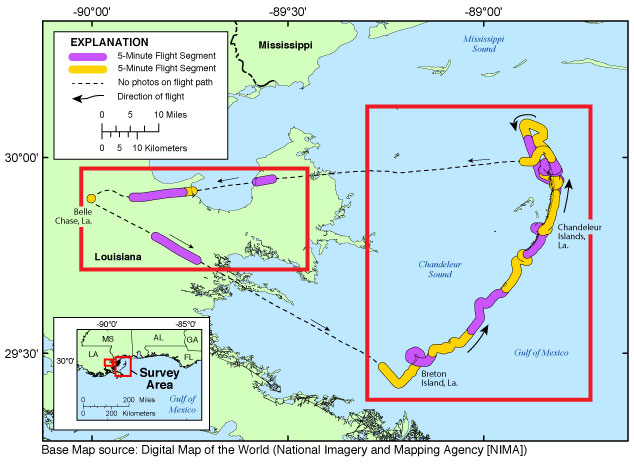
Figure 1. Map of Breton Island and the Chandeleur Islands, Louisiana.
Data
| File Name and Description | Metadata (XML format) | Metadata (text format) | Download File |
|---|---|---|---|
| 11CCH01-LocationMaps.zip
Maps showing the division of the flight into areas and the flight path in each area in 5-minute segments (.jpg) |
11CCH01-Metadata.xml (20 KB) |
11CCH01-Metadata.txt (20 KB) |
11CCH01-LocationMaps.zip (250 KB) |
| 11CCH01-ProcessedNav.zip Processed navigation files, includes flightpath and photo locations (.csv) |
Same as above | Same as above | 11CCH01-ProcessedNav.zip (66 KB) |
| 11CCH01-RawGPSNav.zip Garmin GPSMAP 60CSx raw navigation file (.txt) |
Same as above | Same as above | 11CCH01-RawGPSNav.zip (55 KB) |
| 11CCH01_0122_151500.zip Images for Survey Area |
Same as above | Same as above | 11CCH01_0122_151500.zip (270 KB) |
| 11CCH01_0122_152000.zip Images for Survey Area |
Same as above | Same as above | 11CCH01_0122_152000.zip (254 KB) |
| 11CCH01_0122_153500.zip Images for Survey Area |
Same as above | Same as above | 11CCH01_0122_153500.zip (25 MB) |
| 11CCH01_0122_154000.zip Images for Survey Area |
Same as above | Same as above | 11CCH01_0122_154000.zip (144 MB) |
| 11CCH01_0122_154500.zip Images for Survey Area |
Same as above | Same as above | 11CCH01_0122_154500.zip (80 MB) |
| 11CCH01_0122_155000.zip Images for Survey Area |
Same as above | Same as above | 11CCH01_0122_155000.zip (59 MB) |
| 11CCH01_0122_155500.zip Images for Survey Area |
Same as above | Same as above | 11CCH01_0122_155500.zip (51 MB) |
| 11CCH01_0122_160000.zip Images for Survey Area |
Same as above | Same as above | 11CCH01_0122_160000.zip (185 MB) |
| 11CCH01_0122_160500.zip Images for Survey Area |
Same as above | Same as above | 11CCH01_0122_160500.zip (156 MB) |
| 11CCH01_0122_161000.zip Images for Survey Area |
Same as above | Same as above | 11CCH01_0122_161000.zip (236 MB) |
| 11CCH01_0122_161500.zip Images for Survey Area |
Same as above | Same as above | 11CCH01_0122_161500.zip (111 MB) |
| 11CCH01_0122_162000.zip Images for Survey Area |
Same as above | Same as above | 11CCH01_0122_162000.zip (88 MB) |
| 11CCH01_0122_162500.zip Images for Survey Area |
Same as above | Same as above | 11CCH01_0122_162500.zip (71 MB) |
| 11CCH01_0122_163000.zip Images for Survey Area |
Same as above | Same as above | 11CCH01_0122_163000.zip (85 MB) |
| 11CCH01_0122_163500.zip Images for Survey Area |
Same as above | Same as above | 11CCH01_0122_163500.zip (42 MB) |
| 11CCH01_0122_165000.zip Images for Survey Area |
Same as above | Same as above | 11CCH01_0122_165000.zip (23 MB) |
| 11CCH01_0122_165500.zip Images for Survey Area |
Same as above | Same as above | 11CCH01_0122_165500.zip (11 MB) |
| 11CCH01_0122_170000.zip Images for Survey Area |
Same as above | Same as above | 11CCH01_0122_170000.zip (31 MB) |
| 11CCH01_0122_170500.zip Images for Survey Area |
Same as above | Same as above | 11CCH01_0122_170500.zip (6 MB) |
| Supplemental information | |||
| 11CCH01-SupplementalFiles.zip Includes Field Activity Collection System (FACS) logs, a KML file, and navigation files. |
11CCH01-Metadata.xml (20 KB) |
11CCH01-Metadata.txt (20 KB) |
11CCH01-SupplementalFiles.zip (170 KB) |
Suggested Citation
Morgan, K.L.M., and Westphal, K.A., 2017, Baseline coastal oblique aerial photographs collected at Breton Island and the Chandeleur Islands, Louisiana, January 22, 2011: U.S. Geological Survey data release, https://doi.org/10.5066/F7WS8RCP.