In accordance with SO #3423 - The Gulf of America and SO #3424 - Mount McKinley and Landmarks Honoring the Alaskan People, new USGS data releases specific to those named places will utilize the new name Gulf of America and the restored name Mount McKinley. Per USGS practice, historical data will retain the name of the geographic features as they were known at the time the data were originally released.
Data Release
EAARL-B Submerged Topography—Crocker Reef, Florida, 2014
By Xan Fredericks, Christine J. Kranenburg, David B. Nagle, and David G. Zawada
USGS, St. Petersburg, Florida
Summary
These datasets provide lidar-derived topography for a portion of the submerged environs of Crocker Reef, Florida. Elevation measurements were acquired on April 13 and 22, 2014 by the second-generation Experimental Advanced Airborne Research Lidar (EAARL-B).
The authors acknowledge Emily Klipp, Richard Mitchell, Karen Morgan, Chris Pali, Virgil Rabine, Rudy Troche, and Wayne Wright for planning efforts, data acquisition, and processing support.
Data
| File Name and Description | Metadata (XML format) | Metadata (text format) | Download File |
|---|---|---|---|
| CRKR2014_EAARLB_z17_n88g12A_mosaic.zip Lidar-derived submerged topography DEM mosaic for a portion of the submerged environs of Crocker Reef, Florida (.tif) |
CRKR2014_EAARLB_z17_n88g12A_ mosaic_metadata.xml |
CRKR2014_EAARLB_z17_n88g12A_ mosaic_metadata.txt |
CRKR2014_EAARLB_z17_n88g12A_ mosaic.zip (132 MB) |
| CRKR2014_EAARLB_z17_n88g12A.zip Lidar-derived submerged topography point cloud for a portion of the submerged environs of Crocker Reef, Florida (.xyz) |
CRKR2014_EAARLB_z17_n88g12A_ metadata.xml |
CRKR2014_EAARLB_z17_n88g12A_ metadata.txt |
CRKR2014_EAARLB_z17_n88g12A.zip (205 MB) |
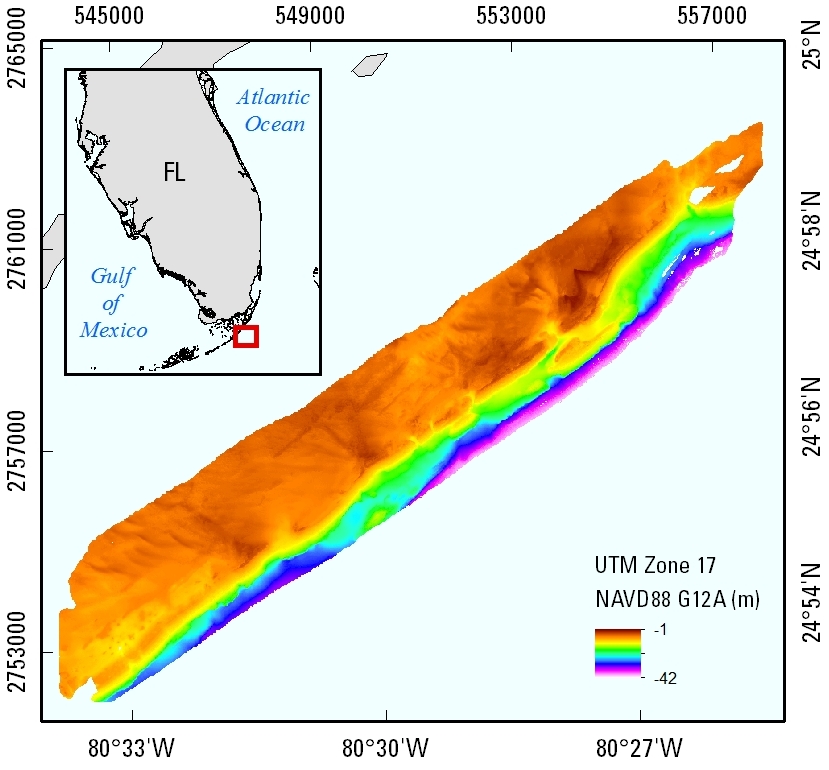
Figure 1. Lidar-derived submerged topography extent for Crocker Reef, Florida; data were collected in April 2014.
Suggested Citation
Fredericks, Xan, Kranenburg, C.J., Nagle, D.B., and Zawada, D.G., 2016, EAARL-B Submerged Topography—Crocker Reef, Florida, 2014: U.S. Geological Survey data release, https://doi.org/10.5066/F7ZW1J25.