Data Release
Shore Proximal Marsh Sediment Deposition and Ancillary Data From Grand Bay National Estuarine Research Reserve, Mississippi, From October 2020 to January 2023
By Joseph F. Terrano,1 Alisha M. Ellis,2 Kathryn E.L. Smith,1 Jonathan Pitchford,3 Michael Archer,3 Joseph M. Vargas,4 Jonathan P. Griffiths,4 Samuel M. Randall,5 Matthew Virden,6 Cheyenne S. Everhart,5 and Eric Sparks6
1 U.S. Geological Survey, St. Petersburg Coastal and Marine Science Center
2 U.S. Geological Survey, Energy and Minerals Mission Area
3 Grand Bay National Estuarine Research Reserve, Mississippi
4 Formerly Cherokee Nation System Solutions contracted to the U.S. Geological Survey
5 Formerly U.S. Geological Survey
6 Mississippi State University, Mississippi
Summary
To better understand sediment deposition in marsh environments, scientists from the U.S. Geological Survey, St. Petersburg Coastal and Marine Science Center (USGS-SPCMSC) selected five marsh study sites (Sites 5, 6, 7, 8, and 9) and four nearshore estuarine study sites (Sites 8S, 8D, 9S, 9D) along the Point Aux Chenes Bay shoreline of the Grand Bay National Estuarine Research Reserve (GNDNERR), Mississippi. This study builds on Smith and others (2020b) and includes datasets collected after the installation of a living shoreline (a subtidal sill [artificial reef]) that was completed in May 2021. Each marsh site consisted of five plots located along a transect perpendicular to the marsh-estuary shoreline at 5-meter (m) increments (5, 10, 15, 20, and 25 m from the shoreline). Each plot contained three to six net sedimentation tiles (NST) that were secured flush to the marsh surface using polyvinyl chloride (PVC) pipe. NST are an inexpensive and simple tool to assess short- and long-term deposition that can be deployed in highly dynamic environments without the compaction associated with traditional coring methods. The NST were deployed for three-month sampling periods, measuring sediment deposition from August 2021 to January 2023. Sediment deposited on the NST were processed to determine physical characteristics, such as deposition thickness, volume, wet weight/dry weight, grain size, and organic content (via loss-on-ignition [LOI]). For select sampling periods, ancillary data (water level, elevation, and vegetation) are also provided in this data release. The estuarine sites consisted of Site 8S (shallow; landward of the subtidal sill), 8D (deep; seaward side of the subtidal sill), as well as 9S and 9D (both sites established adjacent to 8S/8D and the subtidal sill). During select trips water parameters (e.g., waves, water level, and turbidity) were collected at each estuarine site to collect turbidity and wave data. Data presented in this data release were collected under three USGS Field Activities Numbers (FAN; one FAN per year) during thirteen sampling trips (alternate FAN; each sampling trip was assigned a unique alt FAN under the main FAN): 2021-320-FA (21CCT01, 21CCT03, 21CCT04, 21CCT05), 2022-302-FA (22CCT01, 22CCT02, 22CCT03, 22CCT04, 22CCT05, 22CCT06, 22CCT07, 22CCT08) and 2023-301-FA (23CCT01), however, every trip does not contain all data types. This data release also contains data for 2020-323-FA (20CCT02) that was collected as a special collection trip for Hurricane Delta. However, this data was collected before the subtidal sill was installed and is being published with this data release since pre-subtidal sill data was already published. Data from a related NST study in the GNDNERR (Middle Bay and North Rigolets) can be found in Smith and others (2020a). Data collected from before the living shoreline (subtidal sill) installation can be found in Smith and others (2020b). For additional information on data processing and analysis, refer to the accompanying journal publication Smith and others (2025). Please read the full metadata for details on data collection, dataset variables, and data quality.
Smith, K.E.L., Terrano, J.F., Khan, N.S., and Stalk, C.A., 2020a, Shore proximal sediment deposition, elevation, turbidity, and water level data for four sites in the coastal marsh at Grand Bay National Estuarine Research Reserve, Mississippi, from October 2016 through October 2017: U.S. Geological Survey data release, https://doi.org/10.5066/P9BFR2US.
Smith, K.E.L., Terrano, J.F., Pitchford, J., Brochard M., Vargas, J.M., Atchia, I.D., Everhart, C.S., and Smith C.G., 2020b, Shore proximal marsh sediment deposition and ancillary data from Grand Bay National Estuarine Research Reserve, Mississippi, from July 2018 to January 2020 (ver. 2.0, June 2023): U.S. Geological Survey data release, https://doi.org/10.5066/P9ONI8PS.
Smith, K.E.L., Pitchford, J., Sparks, E.L., Archer, M.J., Virden M.F., Terrano, J.F., and Smith C.G., 2025, Evaluating the influence of constructed subtidal reefs on marsh shoreline erosion, sediment deposition, and wave energy: Estuaries and Coasts, v. 48, no. 128, https://doi.org/10.1007/s12237-025-01564-7.
Data
| File Name and Description | Metadata (XML format) | Metadata (text format) | Download File |
|---|---|---|---|
| GB_AquaTroll_Data_2022_2023.zip Water parameters collected using Aqua TROLL 600 sensors (.csv) |
GB_AquaTroll_2022_2023_ Metadata.xml |
GB_AquaTroll_2022_2023_ Metadata.txt |
GB_AquaTroll_Data_2022_2023.zip (7 MB) |
| GB_Elevation_Data_2020_2023.zip Location and elevation data (.csv) |
GB_Elevation_2020_2023_ Metadata.xml |
GB_Elevation_2020_2023_ Metadata.txt |
GB_Elevation_Data_2020_2023.zip (205 KB) |
| GB_Net_Sedimentation_Tile_Data_2020_2023.zip Sediment deposition and physical characteristics for Net Sediment Tiles (NST). Also contains grain size analysis and an associated data dictionary (.csv, .docx) |
GB_NST_and_Surface_sediment_ 2020_2023_Metadata.xml |
GB_NST_and_Surface_sediment_ 2020_2023_Metadata.txt |
GB_Net_Sedimentation_ Tile_Data_2020_2023.zip (91 KB) |
| GB_SurfaceSediment_Data_2021_2023.zip Sediment physical characteristics for surface samples collected adjacent to the NST plots. Also contains grain size analysis data and an associated data dictionary (.csv, .docx) |
Same as above | Same as above | GB_SurfaceSediment_Data_ 2021_2023.zip (75 KB) |
| GB_RBR_Wave_Data_2021_2023.zip RBR sensor wave data (.csv, .docx) |
GB_RBR_Wave_ 2021_2023_Metadata.xml |
GB_RBR_Wave_ 2021_2023_Metadata.txt |
GB_RBR_Wave_Data_2021_2023.zip (2.4 MB) |
| GB_Vegetation_Data_2021_2022.zip Plot vegetation survey data (.csv) |
GB_Vegetation_ 2021_2022_Metadata.xml |
GB_Vegetation_ 2021_2022_Metadata.txt |
GB_Vegetation_Data_2021_2022.zip (15 KB) |
| GB_Water_Level_Data_2021_2023.zip Water level logger data (.csv, .html) |
GB_Water_Level_ 2021_2023_Metadata.xml |
GB_Water_Level_ 2021_2023_Metadata.txt |
GB_Water_Level_Data_2021_2023.zip (4.4 MB) |
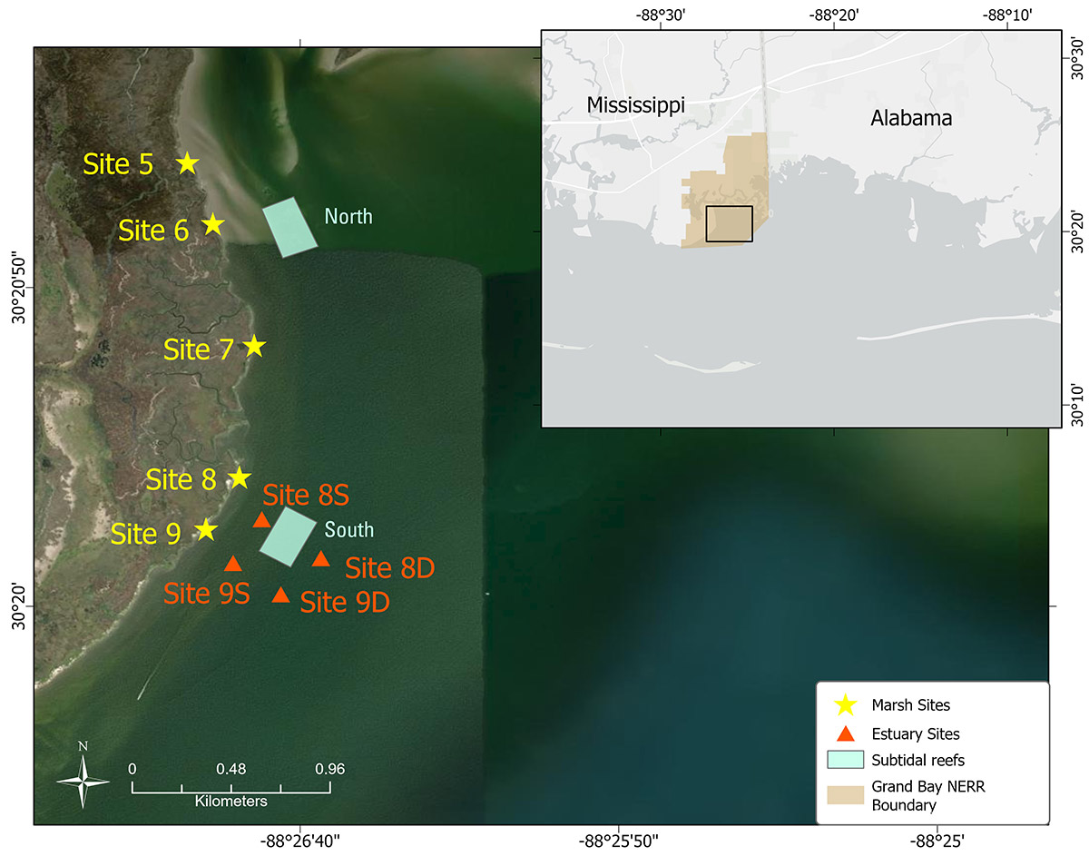
Figure 1. Location of five coastal marsh study sites, four estuarine sensor sites, and two artificial subtidal sills (reefs) located in the Grand Bay National Estuarine Research Reserve, Mississippi.
Suggested Citation
Terrano, J.F., Ellis, A.M., Smith, K.E.L., Pitchford, J., Archer, M., Vargas, J.M., Griffiths, J.P., Randall, S.M., Virden, M., Everhart, C.S., and Sparks, E., 2025, Shore proximal marsh sediment deposition and ancillary data from Grand Bay National Estuarine Research Reserve, Mississippi, from October 2020 to January 2023: U.S. Geological Survey data release, https://doi.org/10.5066/P13VT3ET.