In accordance with SO #3423 - The Gulf of America and SO #3424 - Mount McKinley and Landmarks Honoring the Alaskan People, new USGS data releases specific to those named places will utilize the new name Gulf of America and the restored name Mount McKinley. Per USGS practice, historical data will retain the name of the geographic features as they were known at the time the data were originally released.
Data Release
USGS CoastCam at Waiakāne, Moloka'i, Hawai'i: 2018 Calibration and GNSS Topography Survey Data
By Shawn R. Harrison,1 Mark L. Buckley,2 Joshua Logan,3Andrew W.M. Pomeroy,4 Curt D. Storlazzi,3 Justin J. Birchler,2 Margaret L. Palmsten,2 Eric Swanson,5 and Emily L. Johnson2
1 Ocean Sciences Division, U.S. Naval Research Laboratory, Stennis Space Center, MS
2 USGS St. Petersburg Coastal and Marine Science Center, St. Petersburg, Florida
3 USGS Pacific Coastal and Marine Science Center, Santa Cruz, California
4 National Centre for Coasts and Climate, School of BioSciences, The University of Melbourne, VIC 3010, Australia
5 Cherokee Nation System Solutions, St. Petersburg, Florida
Summary
A digital video camera was installed at Waiakāne, Moloka'i, Hawai'i (HI) and faced west along the beach. Every hour during daylight hours, daily from June 26, 2018, to September 20, 2018, the camera collected raw video and produced snapshots and time-averaged image products. This data release includes the necessary intrinsic orientation (IO) and extrinsic orientation (EO) calibration data to utilize imagery to make quantitative measurements. The camera is part of a U.S. Geological Survey (USGS) research project to study the beach and nearshore environment. USGS researchers analyzed the imagery collected from this camera to remotely sense a range of information including shoreline position, sandbar migration, wave run-up on the beach, alongshore currents, and nearshore bathymetry. This camera is part of the USGS CoastCam network, supported by the Total Water Level/Coastal Change Project under the Coastal and Marine Hazards and Resources Program (CMHRP). To learn more about this specific camera visit https://www.usgs.gov/programs/cmhrp/science/usgs-coastcams.
Distribution Statement A. Approved for public release. Distribution is unlimited.
Data
| File Name and Description | Metadata (XML format) | Metadata (text format) | Download File |
|---|---|---|---|
| MolokaiHI_c2_20180625_IO.zip Images to solve camera intrinsic orientation along with solved parameters (.jpg, .yaml) |
MolokaiHI_c2_calibration_ metadata.xml |
MolokaiHI_c2_calibration_ metadata.txt |
MolokaiHI_c2_20180625_IO.zip (50.4 MB) |
| MolokaiHI_c2_20180626_EO.zip Images to solve camera extrinsic orientation (raw and annotated) along with solved parameters and Ground Control Point (GCP) data (.jpg, .csv, .yaml) |
Same as above | Same as above | MolokaiHI_c2_20180626_EO.zip (1.21 MB) |
| MolokaiHI_c2_20180625_ calibrationIOEO_ exampleImagery.zip Example imagery used to solve intrinsic and extrinsic parameters (.jpg) |
Same as above | Same as above | MolokaiHI_c2_20180625_ calibrationIOEO_ exampleImagery.zip (1.40 MB) |
| MolokaiHI_XYZ_20180626.zip Post-processed GNSS ground-survey data. (.txt) |
MolokaiHI_XYZ_20180626_ metadata.xml |
MolokaiHI_XYZ_20180626_ metadata.txt |
MolokaiHI_XYZ_20180626.zip (25 KB) |
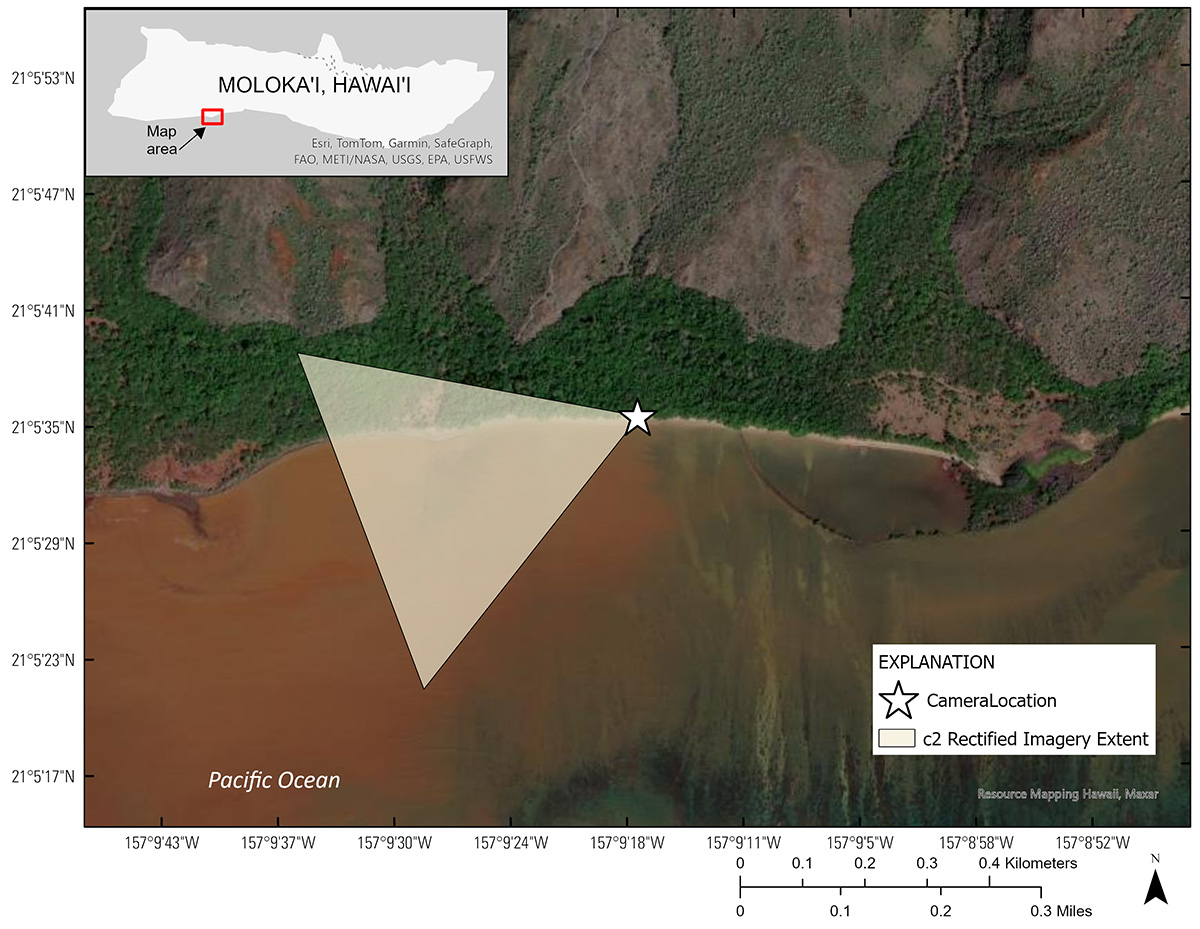
Figure 1. Regional map showing the CoastCam location (white star) and spatial extent of rectified imagery at Waiakāne, Moloka'i, Hawai'i.
Suggested Citation
Harrison, S.R., Buckley, M.L., Logan, J., Pomeroy, A.W.M., Storlazzi, C.D., Birchler, J.J., Palmsten, M.L., Swanson, E., and Johnson, E.L., 2024, USGS CoastCam at Waiakāne, Moloka'i, Hawai'i: 2018 calibration and GNSS topography survey data: U.S Geological Survey data release, https://doi.org/10.5066/P13XN6KM.