In accordance with SO #3423 - The Gulf of America and SO #3424 - Mount McKinley and Landmarks Honoring the Alaskan People, new USGS data releases specific to those named places will utilize the new name Gulf of America and the restored name Mount McKinley. Per USGS practice, historical data will retain the name of the geographic features as they were known at the time the data were originally released.
Data Release
Time Series of Aerial Imagery from Small Unmanned Aircraft Systems and Associated Ground Control Points: Madeira Beach, Florida, July 2017 to June 2018
By Jenna A. Brown, Christine J. Kranenburg, and Karen L.M. Morgan
USGS, St. Petersburg, Florida
Summary
Aerial imagery acquired with a small unmanned aircraft system (sUAS), in conjunction with surveyed ground control points (GCP) visible in the imagery, can be processed with structure-from-motion (SfM) photogrammetry techniques to produce high-resolution orthomosaics, three-dimensional (3D) point clouds and digital elevation models (DEMs). This dataset, prepared by the U.S. Geological Survey (USGS) St. Petersburg Coastal and Marine Science Center (SPCMSC), provides UAS survey data consisting of aerial imagery and GCP positions and elevations collected at Madeira Beach, Florida, monthly from July 2017 to June 2018 in order to observe seasonal and storm-induced changes in beach topography.
Low-altitude (60 meters above ground level) digital aerial imagery were acquired over an approximately 700-meter-long and 100-meter-wide stretch of coastline. A 3DR Solo UAS quadcopter equipped with a Ricoh GR II digital camera flew shore-parallel lines at approximately 8 meters per second, collecting true color imagery at 1 Hertz, resulting in image footprints with 80% endlap/sidelap and 1.6 centimeter ground sample distance (GSD). The approximate camera position at the time of each image capture was interpolated from positions recorded by an internal Global Navigation Satellite System (GNSS) receiver on-board the UAS in a telemetry log file. A number of permanent features (e.g., parking lot stripes, concrete groin blocks) and temporary targets (black and white, 4-square checked pattern), distributed uniformly throughout the UAS flight operations area, were used as GCPs and surveyed using a Spectra Precision SP80 GNSS receiver connected to a Continuously Operating Reference Station (CORS) in the Florida Permanent Reference Network (FPRN); real-time kinematic (RTK) corrections were sampled for 60 seconds and the average positions were recorded, with horizontal position data given in the Universal Transverse Mercator (UTM) projected coordinate system, Zone 17 North (17N), referenced to the North American Datum of 1983 (NAD83), and elevation data referenced to the North American Vertical Datum of 1988 (NAVD88), GEOID12B.
Related Data Release
Brown, J.A., Kranenburg, C.J., and Morgan, K.L.M., 2020, Time series of structure-from-motion products—Orthomosaics, digital elevation models, and point clouds: Madeira Beach, Florida, July 2017 to June 2018: U.S. Geological Survey data release, https://doi.org/10.5066/P9L474WC.
Data
| File Name and Description | Metadata (XML format) | Metadata (text format) | Download File |
|---|---|---|---|
| 2017-2018_MadeiraBeachFL_GCPs.zip GCP positions for each UAS survey (.txt) |
2017-2018_MadeiraBeachFL_ GCPs_metadata.xml |
2017-2018_MadeiraBeachFL_ GCPs_metadata.txt |
2017-2018_MadeiraBeachFL_GCPs.zip (24 KB) |
| 20170712_MadeiraBeachFL_UAS_Imagery.zip July 2017 low-altitude aerial imagery obtained from UAS (.jpg) |
MadeiraBeachFL_UAS_ Imagery_metadata.xml |
MadeiraBeachFL_UAS_ Imagery_metadata.txt |
20170712_MadeiraBeachFL_UAS_Imagery.zip (3.07 GB) |
| 20170816_MadeiraBeachFL_UAS_Imagery.zip August 2017 low-altitude aerial imagery obtained from UAS (.jpg) |
Same as above | Same as above | 20170816_MadeiraBeachFL_UAS_Imagery.zip (7.56 GB) |
| 20170914_MadeiraBeachFL_UAS_Imagery.zip September 2017 low-altitude aerial imagery obtained from UAS (.jpg) |
Same as above | Same as above | 20170914_MadeiraBeachFL_UAS_Imagery.zip (9.74 GB) |
| 20171011_MadeiraBeachFL_UAS_Imagery.zip October 2017 low-altitude aerial imagery obtained from UAS (.jpg) |
Same as above | Same as above | 20171011_MadeiraBeachFL_UAS_Imagery.zip (10.62 GB) |
| 20171109_MadeiraBeachFL_UAS_Imagery.zip November 2017 low-altitude aerial imagery obtained from UAS (.jpg) |
Same as above | Same as above | 20171109_MadeiraBeachFL_UAS_Imagery.zip (9.75 GB) |
| 20171211_MadeiraBeachFL_UAS_Imagery.zip December 2017 low-altitude aerial imagery obtained from UAS (.jpg) |
Same as above | Same as above | 20171211_MadeiraBeachFL_UAS_Imagery.zip (7.36 GB) |
| 20180124_MadeiraBeachFL_UAS_Imagery.zip January 2018 low-altitude aerial imagery obtained from UAS (.jpg) |
Same as above | Same as above | 20180124_MadeiraBeachFL_UAS_Imagery.zip (4.94 GB) |
| 20180222_MadeiraBeachFL_UAS_Imagery.zip February 2018 low-altitude aerial imagery obtained from UAS (.jpg) |
Same as above | Same as above | 20180222_MadeiraBeachFL_UAS_Imagery.zip (8.77 GB) |
| 20180309_MadeiraBeachFL_UAS_Imagery.zip March 2018 low-altitude aerial imagery obtained from UAS (.jpg) |
Same as above | Same as above | 20180309_MadeiraBeachFL_UAS_Imagery.zip (7.49 GB) |
| 20180411_MadeiraBeachFL_UAS_Imagery.zip April 2018 low-altitude aerial imagery obtained from UAS (.jpg) |
Same as above | Same as above | 20180411_MadeiraBeachFL_UAS_Imagery.zip (9.28 GB) |
| 20180522_MadeiraBeachFL_UAS_Imagery.zip May 2018 low-altitude aerial imagery obtained from UAS (.jpg) |
Same as above | Same as above | 20180522_MadeiraBeachFL_UAS_Imagery.zip (9.48 GB) |
| 20180619_MadeiraBeachFL_UAS_Imagery.zip June 2018 low-altitude aerial imagery obtained from UAS (.jpg) |
Same as above | Same as above | 20180619_MadeiraBeachFL_UAS_Imagery.zip (8.57 GB) |
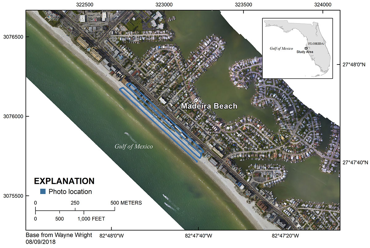
Figure 1. Regional map showing the survey area at Madeira Beach, Florida.
Suggested Citation
Brown, J.A., Kranenburg, C.J., and Morgan, K.L.M., 2020, Time series of aerial imagery from small unmanned aircraft systems and associated ground control points: Madeira Beach, Florida, July 2017 to June 2018: U.S. Geological Survey data release, https://doi.org/10.5066/P91TH157.