In accordance with SO #3423 - The Gulf of America and SO #3424 - Mount McKinley and Landmarks Honoring the Alaskan People, new USGS data releases specific to those named places will utilize the new name Gulf of America and the restored name Mount McKinley. Per USGS practice, historical data will retain the name of the geographic features as they were known at the time the data were originally released.
Data Release
iCoast - Did the Coast Change? Crowd-Sourced Coastal Classifications for Hurricane Sandy
By Karen L.M. Morgan, Richard J. Snell, and Nathaniel G. Plant
USGS, St. Petersburg, Florida
Summary
On October 29, 2012, Hurricane Sandy made landfall as a post-tropical storm near Brigantine, New Jersey, with sustained winds of 70 knots (80 miles per hour) and tropical-storm-force winds extending 870 nautical miles in diameter (Blake, et. al, 2013). The effects of Sandy’s winds and storm surge included erosion of the beaches and dunes as well as breaching of barrier islands in both natural and heavily developed areas of the coast (Spokin et. al., 2014). On November 4–6, 2012, the U.S. Geological Survey (USGS) conducted an aerial survey of the coast from Cape Lookout, North Carolina, to Montauk Point, New York (Morgan and Krohn, 2014) collecting nearly 10,000 images during three days of surveying.
In June 2014, the USGS developed a crowd-sourced online application, “iCoast – Did the Coast Change?” to enlist the help of citizen scientists (referred to as “users”) in the classification of coastal infrastructure, coastal processes, and storm impacts related to Hurricane Sandy. Hurricane Sandy was chosen as the inaugural project due to the broad range of impacts from the storm. By enlisting citizen scientists in the analysis of these images, the iCoast offers a chance to classify all the imagery from Hurricane Sandy in a form that scientists can use to analyze and verify predictive vulnerability models. This user audience spanned a wide range of expertise as well as enlisting anyone interested in coastal issues, including coastal researchers and emergency managers to coastal residents, students, and professors.
The data presented here represents the classification of imagery by iCoast users as of September 9, 2016. At that time all of the post-Hurricane Sandy images had at least one user classification. The data includes user classifications of the coastal type, level of development, visible infrastructure, damage to visible infrastructure, and determination of the dominant coastal process in the image based on Sallenger’s (2000) coastal impact scale.
Data
| File Name and Description | Metadata (XML format) | Metadata (text format) | Download File |
|---|---|---|---|
| iCoast-All-Classifications-2012-Hurricane-Sandy-20160909.zip List of all iCoast classifications as of September 9, 2016 (.csv) |
iCoast-metadata.xml (32 KB) |
iCoast-metadata.txt (33 KB) |
iCoast-All-Classifications-2012-Hurricane-Sandy-20160909.zip (1.1 MB) |
| iCoast-Tag-Selection-Frequencies-2012-Hurricane-Sandy-20160909.zip List of all available iCoast tags and how often they were selected (.csv) |
Same as above | Same as above | iCoast-Tag-Selection-Frequencies-2012-Hurricane-Sandy-20160909.zip (16 KB) |
| iCoast-User-Classification-Summary-2012-Hurricane-Sandy-20160909.zip List of user ID numbers, number of attempted and number they completed (.csv) |
Same as above | Same as above | iCoast-User-Classification-Summary-2012-Hurricane-Sandy-20160909.zip (19 KB) |
| iCoast-UserCrowdTypes.zip List of user crowd types found in iCoast (.txt) |
Same as above | Same as above | iCoast_UserCrowdTypes.zip (11 KB) |
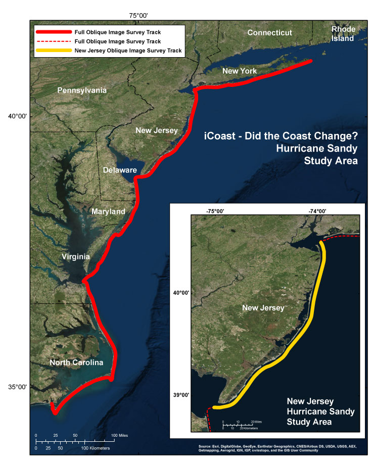
Figure 1. Study area for iCoast - Did the Coast Change?, Hurricane Sandy project.
References
Blake, E.S., Kimberlain, T.B., Berg, R.J., Cangialosi J.P. and Beven II, J.L., 2013, Tropical Cyclone Report Hurricane Sandy (AL182012) 22–29 October 2012, National Hurricane Center, 2013, accessed May 1, 2018, at https://www.nhc.noaa.gov/data/tcr/AL182012_Sandy.pdf.
Sopkin, K.L., Stockdon, H.F., Doran, K.S., Plant, N.G., Morgan, K.L.M., Guy, K.K., and Smith, K.E.L., 2014, Hurricane Sandy—Observations and analysis of coastal change: U.S. Geological Survey Open-File Report 2014–1088, 54 p., accessed May 1, 2018, at https://doi.org/10.3133/ofr20141088.
Morgan, K.L.M., and Krohn, M.D., 2014, Post-Hurricane Sandy coastal oblique aerial photographs collected from Cape Lookout, North Carolina, to Montauk, New York, November 4–6, 2012: U.S. Geological Survey Data Series 858, accessed May 1, 2018, at https://doi.org/10.3133/ds858.
Sallenger, A.H., Jr., 2000, Storm impact scale for barrier islands: Journal of Coastal Research, v. 16 no. 3, p. 890–895 [available at https://www.jstor.org/stable/4300099].
Suggested Citation
Morgan, K.L.M., Snell, R.J., and Plant, N.G., 2018, iCoast - Did the coast change? Crowd-sourced coastal classifications for Hurricane Sandy: U.S. Geological Survey data release, https://doi.org/10.5066/P93A9MPE.