In accordance with SO #3423 - The Gulf of America and SO #3424 - Mount McKinley and Landmarks Honoring the Alaskan People, new USGS data releases specific to those named places will utilize the new name Gulf of America and the restored name Mount McKinley. Per USGS practice, historical data will retain the name of the geographic features as they were known at the time the data were originally released.
Data Release
Shoreline Change Analysis for the Grand Bay National Estuarine Research Reserve, Mississippi Alabama: 1848 to 2017
By Joseph F. Terrano,1 Kathryn E.L. Smith,2 Jonathan Pitchford,3 Julius McIlwain,3 and Michael Archer 3
1 University of South Florida, contracted to the U.S. Geological Survey
2 U.S. Geological Survey
3 Grand Bay National Estuarine Research Reserve, Mississippi
Summary
Throughout the northern Gulf of Mexico, marsh shorelines are eroding due to wave attack, sea-level rise and subsidence. Shoreline erosion results in net marsh loss when transgression rates at the marsh-water edge exceed upland-marsh migration. Coastal marsh serves important ecologic and economic functions, such as providing habitat, absorbing floodwaters and storm surges, and coastal carbon sequestration. Therefore, the rate and processes of shoreline change are important considerations when evaluating the overall health and vulnerability of coastal marshes to future scenarios of sea-level rise, climate change, and global carbon budget.
The data presented here include compiled vectorized marsh shorelines and transects with shoreline change rates for the Grand Bay National Estuarine Research Reserve in Mississippi and Alabama from 1848 to 2017. The shoreline change rates have been updated and republished in Terrano and others (2024). Shoreline change was calculated from digital vector shorelines acquired from historical topographic sheets, aerial photography, or global positioning system (GPS) data. Shoreline change rates are estimated from the shoreline position of multiple dated datasets utilizing the intersection with a perpendicular transect to the congregate shoreline. These analyses were conducted using the Analyzing Movement Boundaries Using R (AMBUR) package. For additional information on AMBUR, see Jackson, C.W., Jr., 2010. Basic User Guide for the AMBUR package for R, version 1.0a.
Terrano, J.F., Smith, K.E.L., Pitchford, J., Archer, M., and Jenkins III, R.L., 2024, Estuarine shoreline, upland boundary, and marsh habitat change analyses for the Point Aux Chenes and Grand Bay estuary systems, Mississippi and Alabama: U.S. Geological Survey data release, https://doi.org/10.5066/P1HZES2R.
Note: This data release was versioned on February 25, 2019. Please see the Suggested Citation section for details.
Data
| File Name and Description | Metadata (XML format) | Metadata (text format) | Download File |
|---|---|---|---|
| Shorelines_1848_2017.zip Shorelines for Grand Bay from 1848 to 2017 (.shp) |
Shorelines_1848_2017_metadata.xml | Shorelines_1848_2017_metadata.txt | Shorelines_1848_2017.zip (11.5 MB) |
| Transects_with_Rates.zip Transects with rates-of-change for Grand Bay from 1848 to 2017 (.shp) | Transects_with_Rates_metadata.xml | Transects_with_Rates_metadata.txt | Transects_with_Rates.zip (521 KB) |
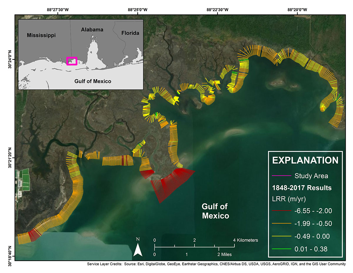
Figure 1. Long-term (1848–2017) shoreline change results using GIS and GPS shorelines.
Suggested Citation
Terrano, J.F., Smith, K.E.L., Pitchford, J., McIlwain, J., and Archer, M., 2018, Shoreline change analysis for the Grand Bay National Estuarine Research Reserve, Mississippi Alabama—1848 to 2017 (ver. 2.0, February 2019): U.S. Geological Survey data release, https://doi.org/10.5066/P9JMA8WK.
First posted September 26, 2018
Revised February 25, 2019, ver. 2.0