In accordance with SO #3423 - The Gulf of America and SO #3424 - Mount McKinley and Landmarks Honoring the Alaskan People, new USGS data releases specific to those named places will utilize the new name Gulf of America and the restored name Mount McKinley. Per USGS practice, historical data will retain the name of the geographic features as they were known at the time the data were originally released.
Data Release
Time Series of Structure-from-Motion Products—Orthomosaics, Digital Elevation Models, and Point Clouds: Madeira Beach, Florida, July 2017 to June 2018
By Jenna A. Brown, Christine J. Kranenburg, and Karen L.M. Morgan
USGS, St. Petersburg, Florida
Summary
Aerial imagery acquired with a small unmanned aircraft system (sUAS), in conjunction with surveyed ground control points (GCP) visible in the imagery, can be processed with structure-from-motion (SfM) photogrammetry techniques to produce high-resolution orthomosaics, three-dimensional (3D) point clouds and digital elevation models (DEMs). This dataset, prepared by the U.S. Geological Survey (USGS) St. Petersburg Coastal and Marine Science Center (SPCMSC), provides UAS survey data products consisting of orthomosaics, DEMs and point clouds collected at Madeira Beach, Florida, from July 2017 to June 2018 in order to observe seasonal and storm-induced changes in beach topography.
Photogrammetry software was used to perform SfM processing on low-altitude digital aerial imagery acquired with a 3DR Solo UAS quadcopter equipped with a Ricoh GR II digital camera, using surveyed permanent features (e.g., parking lot stripes, concrete groin blocks) and temporary targets (black and white, 4-square checked pattern) distributed uniformly throughout the UAS flight operations area as GCPs. The following SfM products are produced for each UAS survey over the approximately 700-meter-long and 100-meter-wide stretch of coastline:
- georeferenced orthomosaic image with 5-centimeter resolution
- DEM with 5-centimeter horizontal resolution
- 3D RGB-colored point cloud
All horizontal data is given in Universal Transverse Mercator (UTM) projected coordinate system, Zone 17 North (17N), referenced to the North American Datum of 1983 (NAD83 (2011)), and elevation is referenced to the North American Vertical Datum of 1988 (NAVD88), GEOID12B.
Related Data Release
Brown, J.A., Kranenburg, C.J., and Morgan, K.L.M., 2020, Time series of aerial imagery from small unmanned aircraft systems and associated ground control points: Madeira Beach, Florida, July 2017 to June 2018: U.S. Geological Survey data release, https://doi.org/10.5066/P91TH157.
Data
| File Name and Description | Metadata (XML format) | Metadata (text format) | Download File |
|---|---|---|---|
| 20170712_MadeiraBeachFL_SfMproducts.zip July 2017 orthomosaic, DEM, and point cloud (.tif, .laz) |
MadeiraBeachFL_SfMproducts_ ortho_metadata.xml MadeiraBeachFL_SfMproducts_ DEM_metadata.xml MadeiraBeachFL_SfMproducts_ ptcloud_metadata.xml |
MadeiraBeachFL_SfMproducts_ ortho_metadata.txt MadeiraBeachFL_SfMproducts_ DEM_metadata.txt MadeiraBeachFL_SfMproducts_ ptcloud_metadata.txt |
20170712_MadeiraBeachFL_ SfMproducts.zip (1.3 GB) |
| 20170816_MadeiraBeachFL_SfMproducts.zip August 2017 orthomosaic, DEM, and point cloud (.tif, .laz) |
Same as above | Same as above | 20170816_MadeiraBeachFL_ SfMproducts.zip (1.3 GB) |
| 20170914_MadeiraBeachFL_SfMproducts.zip September 2017 orthomosaic, DEM, and point cloud (.tif, .laz) |
Same as above | Same as above | 20170914_MadeiraBeachFL_ SfMproducts.zip (1.5 GB) |
| 20171011_MadeiraBeachFL_SfMproducts.zip October 2017 orthomosaic, DEM, and point cloud (.tif, .laz) |
Same as above | Same as above | 20171011_MadeiraBeachFL_ SfMproducts.zip (1.6 GB) |
| 20171109_MadeiraBeachFL_SfMproducts.zip November 2017 orthomosaic, DEM, and point cloud (.tif, .laz) |
Same as above | Same as above | 20171109_MadeiraBeachFL_ SfMproducts.zip (1.5 GB) |
| 20171211_MadeiraBeachFL_SfMproducts.zip December 2017 orthomosaic, DEM, and point cloud (.tif, .laz) |
Same as above | Same as above | 20171211_MadeiraBeachFL_ SfMproducts.zip (1.4 GB) |
| 20180124_MadeiraBeachFL_SfMproducts.zip January 2019 orthomosaic, DEM, and point cloud (.tif, .laz) |
Same as above | Same as above | 20180124_MadeiraBeachFL_ SfMproducts.zip (1.8 GB) |
| 20180222_MadeiraBeachFL_SfMproducts.zip February 2018 orthomosaic, DEM, and point cloud (.tif, .laz) |
Same as above | Same as above | 20180222_MadeiraBeachFL_ SfMproducts.zip (1.5 GB) |
| 20180309_MadeiraBeachFL_SfMproducts.zip March 2018 orthomosaic, DEM, and point cloud (.tif, .laz) |
Same as above | Same as above | 20180309_MadeiraBeachFL_ SfMproducts.zip (1.6 GB) |
| 20180411_MadeiraBeachFL_SfMproducts.zip April 2018 orthomosaic, DEM and point cloud (.tif, .laz) |
Same as above | Same as above | 20180411_MadeiraBeachFL_ SfMproducts.zip (1.6 GB) |
| 20180522_MadeiraBeachFL_SfMproducts.zip May 2018 orthomosaic, DEM, and point cloud (.tif, .laz) |
Same as above | Same as above | 20180522_MadeiraBeachFL_ SfMproducts.zip (1.5 GB) |
| 20180619_MadeiraBeachFL_SfMproducts.zip June 2018 orthomosaic, DEM, and point cloud (.tif, .laz) |
Same as above | Same as above | 20180619_MadeiraBeachFL_ SfMproducts.zip (1.7 GB) |
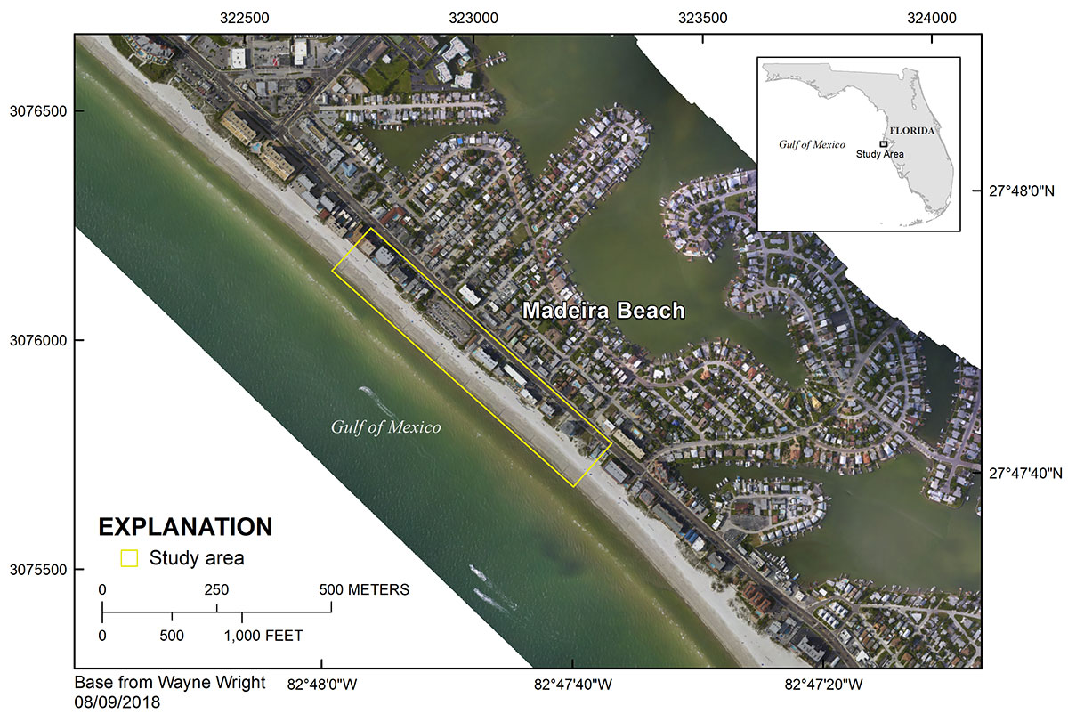
Figure 1. Regional map showing the survey area at Madeira Beach, Florida.
Suggested Citation
Brown, J.A., Kranenburg, C.J., and Morgan, K.L.M., 2020, Time series of structure-from-motion products—orthomosaics, digital elevation models, and point clouds: Madeira Beach, Florida, July 2017 to June 2018: U.S. Geological Survey data release, https://doi.org/10.5066/P9L474WC.