
In accordance with SO #3423 - The Gulf of America and SO #3424 - Mount McKinley and Landmarks Honoring the Alaskan People, new USGS data releases specific to those named places will utilize the new name Gulf of America and the restored name Mount McKinley. Per USGS practice, historical data will retain the name of the geographic features as they were known at the time the data were originally released.
Data Release
National Assessment of Hurricane-Induced Coastal Erosion Hazards: Puerto Rico
By Kara S. Doran,1 Legna M. Torres-Garcia,1 David M. Thompson,1 Justin J. Birchler,1 Kirsten J. Bendik,2 Alex C. Seymour,1 Priscila Vargas-Babilonia,3 Curt D. Storlazzi,4 Mark Buckley,1 Margaret L. Palmsten1
1 U.S. Geological Survey, St. Petersburg Coastal and Marine Science Center
2 Formerly U.S. Geological Survey
3 Student Contractor, U.S. Geological Survey
4 U.S. Geological Survey, Pacific Coastal and Marine Science Center
Summary
These datasets contain information on the probabilities of hurricane-induced erosion (collision, inundation, and overwash) for each 100-meter (m) section of the Puerto Rico open-ocean coastline for category 1–5 hurricanes. The analysis is based on a storm-impact scaling model (Sallenger, 2000; https://www.jstor.org/stable/4300099) that uses observations of beach morphology combined with sophisticated hydrodynamic models to predict how the coast will respond to the direct landfall of category 1–5 hurricanes. Hurricane-induced water levels, due to both surge and waves, are compared to coastal elevations to determine the probabilities of three types of coastal change: collision (dune erosion), overwash, and inundation. Data on dune and cliff morphology (dune crest and toe elevation, cliff top and toe elevation) and hydrodynamics (storm surge, wave setup, and runup) are also included in this dataset. As new morphology observations and storm predictions become available, this analysis will be updated to describe how coastal vulnerability to storms will vary in the future. The data presented here include the dune and cliff morphology observations, as derived from lidar surveys.
For further information regarding data collection and/or processing methods refer to:
Stockdon, H.F., Doran, K.J., Thompson, D.M., Sopkin, K.L., Plant, N.G., and Sallenger, A.H., 2012, National assessment of hurricane-induced coastal erosion hazards—Gulf of Mexico: U.S. Geological Survey Open-File Report 2012–1084, 51 p., https://doi.org/10.3133/ofr20121084.
Data
| File Name and Description | Metadata (XML format) | Metadata (text format) | Download File |
|---|---|---|---|
| PR_PCOI_line.zip Probabilities of hurricane-induced erosion (collision, inundation and overwash) for each 100-m section of the Puerto Rico open-ocean coast for category 1–5 hurricanes (.shp) |
PR_PCOI_metadata.xml | PR_PCOI_metadata.txt | PR_PCOI_line.zip (472 KB) |
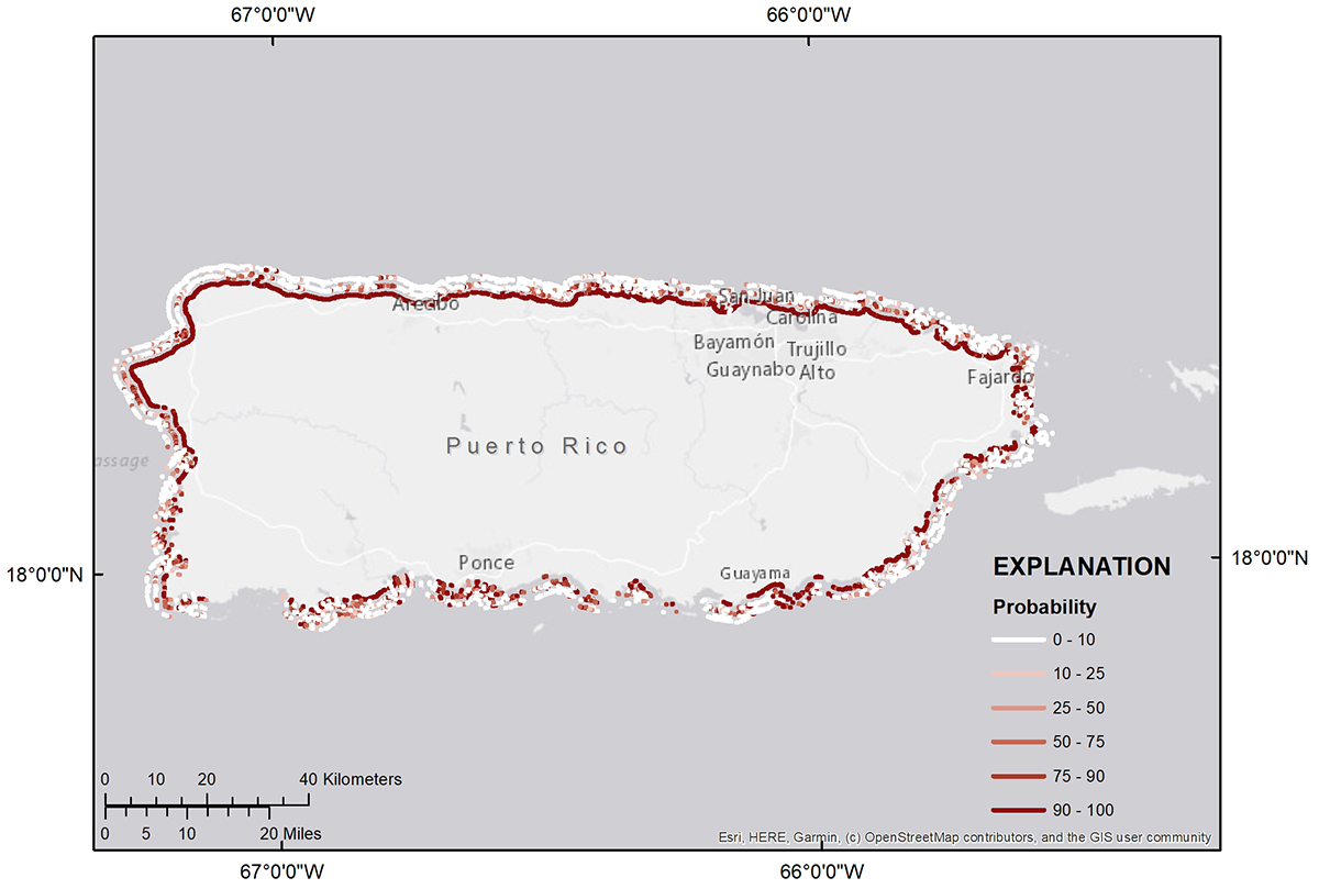
Figure 1. Probabilities of collision (inner strip), overwash (middle strip), and inundation (outer strip) for a Category 1 hurricane.
Suggested Citation
Doran, K.S., Torres-Garcia, L.M., Thompson, D.M., Birchler, J.J., Bendik, K.J., Seymour, A.C., Vargas-Babilonia, P., Storlazzi, C.D., Buckley, M., and Palmsten, M.L., 2022, National assessment of hurricane-induced coastal erosion hazards: Puerto Rico: U.S. Geological Survey data release, https://doi.org/10.5066/P9N01XLQ.