In accordance with SO #3423 - The Gulf of America and SO #3424 - Mount McKinley and Landmarks Honoring the Alaskan People, new USGS data releases specific to those named places will utilize the new name Gulf of America and the restored name Mount McKinley. Per USGS practice, historical data will retain the name of the geographic features as they were known at the time the data were originally released.
Data Release
Aerial Imagery of the North Carolina Coast: 2020-05-08 to 2020-05-09
By Christine J. Kranenburg,1 Andrew C. Ritchie,2 Jenna A. Brown,3 Jin-Si R. Over,4 Christopher R. Sherwood,4 Jonathan A. Warrick,2 and Phillipe A. Wernette2
1 USGS St. Petersburg Coastal and Marine Science Center, St. Petersburg, Florida
2 USGS Pacific Coastal and Marine Science Center, Santa Cruz, California
3 USGS Maryland-Delaware-District of Columbia Water Science Center, Dover, Delaware
4 USGS Woods Hole Coastal and Marine Science Center, Woods Hole, Massachusetts
Summary
The U.S. Geological Survey (USGS) Remote Sensing Coastal Change (RSCC) project collects aerial imagery along coastal swaths, in response to storm events, with optimized endlap/sidelap and precise position information to create high-resolution orthomosaics, three-dimensional (3D) point clouds, and digital elevation/surface models (DEMs/DSMs) using Structure-from-Motion (SfM) photogrammetry methods. These products are valuable for measuring topographic and landscape change, and for understanding coastal vulnerability and response to disturbance events.
A nadir (vertical) aerial imagery survey was conducted from Cape Lookout, North Carolina to the Virginia-North Carolina border on May 8th and 9th, 2020, to document recovery conditions eight months after the passage of Hurricane Dorian in September 2019. The observations along the coastline cover an approximately 275-kilometer-long by 300 to 800-meter-wide swath of coastline and encompass both highly developed towns as well as natural, undeveloped areas, including the federal lands of Cape Lookout National Seashore and Cape Hatteras National Seashore. Low altitude (300 meters above ground level) digital aerial imagery were acquired from a manned, fixed-wing aircraft using a Sony A7R 36 Megapixel digital camera, along with precise aircraft navigation Global Navigation Satellite System (GNSS) data. Data were collected in shore-parallel lines, flying at approximately 50 meters per second and capturing true color imagery at 1 Hertz, resulting in image footprints with approximately 75-80% endlap, 60-70% sidelap, and a ground sample distance (GSD) of 5.3 centimeters. The precise time of each image capture (flash event) was recorded, and the corresponding aircraft position was computed during post-processing of the GNSS data; precise image positions can then be determined by accounting for the lever arm offsets between the aircraft GNSS antenna and the camera lens. Position data, provided as latitude/longitude/ellipsoid height, is referenced to the North American Datum of 1983 (NAD83(2011)).
Data
| File Name and Description | Metadata (XML format) | Metadata (text format) | Download File |
|---|---|---|---|
| 2020-05_NC_AreaMaps.zip Detailed “Area” maps showing individual coastline segments corresponding to data files (.jpg) |
2020-05_NC_Imagery_metadata.xml | 2020-05_NC_Imagery_metadata.txt | 2020-05_NC_AreaMaps.zip (1.64 MB) |
| 2020-05_NC_AircraftPositions.zip Post-processed navigation file, including image names and corresponding aircraft positions (.txt) |
Same as above | Same as above | 2020-05_NC_AircraftPositions.zip (265 KB) |
| 2020-05_NC_3433N.zip Aerial imagery within the 3-minute latitude segment north of 34º 33'N (.jpg) |
Same as above | Same as above | 2020-05_NC_3433N.zip (3.5 GB) |
| 2020-05_NC_3436N.zip Aerial imagery within the 3-minute latitude segment north of 34º 36'N (.jpg) |
Same as above | Same as above | 2020-05_NC_3436N.zip (10.5 GB) |
| 2020-05_NC_3439N.zip Aerial imagery within the 3-minute latitude segment north of 34º 39'N (.jpg) |
Same as above | Same as above | 2020-05_NC_3439N.zip (11.1 GB) |
| 2020-05_NC_3442N.zip Aerial imagery within the 3-minute latitude segment north of 34º 42'N (.jpg) |
Same as above | Same as above | 2020-05_NC_3442N.zip (11.9 GB) |
| 2020-05_NC_3445N-a.zip Aerial imagery within a portion of the 3-minute latitude segment north of 34º 45'N (.jpg) |
Same as above | Same as above | 2020-05_NC_3445N-a.zip (11.9 GB) |
| 2020-05_NC_3445N-b.zip Aerial imagery within a portion of the 3-minute latitude segment north of 34º 45'N (.jpg) |
Same as above | Same as above | 2020-05_NC_3445N-b.zip (11.9 GB) |
| 2020-05_NC_3448N-a.zip Aerial imagery within a portion of the 3-minute latitude segment north of 34º 48'N (.jpg) |
Same as above | Same as above | 2020-05_NC_3448N-a.zip (11.5 GB) |
| 2020-05_NC_3448N-b.zip Aerial imagery within a portion of the 3-minute latitude segment north of 34º 48'N (.jpg) |
Same as above | Same as above | 2020-05_NC_3448N-b.zip (11.5 GB) |
| 2020-05_NC_3451N-a.zip Aerial imagery within a portion of the 3-minute latitude segment north of 34º 51'N (.jpg) |
Same as above | Same as above | 2020-05_NC_3451N-a.zip (13.2 GB) |
| 2020-05_NC_3451N-b.zip Aerial imagery within a portion of the 3-minute latitude segment north of 34º 51'N (.jpg) |
Same as above | Same as above | 2020-05_NC_3451N-b.zip (13.2 GB) |
| 2020-05_NC_3454N-a.zip Aerial imagery within a portion of the 3-minute latitude segment north of 34º 54'N (.jpg) |
Same as above | Same as above | 2020-05_NC_3454N-a.zip (14.0 GB) |
| 2020-05_NC_3454N-b.zip Aerial imagery within a portion of the 3-minute latitude segment north of 34º 54'N (.jpg) |
Same as above | Same as above | 2020-05_NC_3454N-b.zip (14.0 GB) |
| 2020-05_NC_3457N-a.zip Aerial imagery within a portion of the 3-minute latitude segment north of 34º 57'N (.jpg) |
Same as above | Same as above | 2020-05_NC_3457N-a.zip (14.2 GB) |
| 2020-05_NC_3457N-b.zip Aerial imagery within a portion of the 3-minute latitude segment north of 34º 57'N (.jpg) |
Same as above | Same as above | 2020-05_NC_3457N-b.zip (14.2 GB) |
| 2020-05_NC_3500N-a.zip Aerial imagery within a portion of the 3-minute latitude segment north of 35º 00'N (.jpg) |
Same as above | Same as above | 2020-05_NC_3500N-a.zip (14.3 GB) |
| 2020-05_NC_3500N-b.zip Aerial imagery within a portion of the 3-minute latitude segment north of 35º 00'N (.jpg) |
Same as above | Same as above | 2020-05_NC_3500N-b.zip (14.3 GB) |
| 2020-05_NC_3503N-a.zip Aerial imagery within a portion of the 3-minute latitude segment north of 35º 03'N (.jpg) |
Same as above | Same as above | 2020-05_NC_3503N-a.zip (13.7 GB) |
| 2020-05_NC_3503N-b.zip Aerial imagery within a portion of the 3-minute latitude segment north of 35º 03'N (.jpg) |
Same as above | Same as above | 2020-05_NC_3503N-b.zip (13.7 GB) |
| 2020-05_NC_3506N-a.zip Aerial imagery within a portion of the 3-minute latitude segment north of 35º 06'N (.jpg) |
Same as above | Same as above | 2020-05_NC_3506N-a.zip (9.2 GB) |
| 2020-05_NC_3506N-b.zip Aerial imagery within a portion of the 3-minute latitude segment north of 35º 06'N (.jpg) |
Same as above | Same as above | 2020-05_NC_3506N-b.zip (9.2 GB) |
| 2020-05_NC_3509N-a.zip Aerial imagery within a portion of the 3-minute latitude segment north of 35º 09'N (.jpg) |
Same as above | Same as above | 2020-05_NC_3509N-a.zip (9.6 GB) |
| 2020-05_NC_3509N-b.zip Aerial imagery within a portion of the 3-minute latitude segment north of 35º 09'N (.jpg) |
Same as above | Same as above | 2020-05_NC_3509N-b.zip (10.7 GB) |
| 2020-05_NC_3512N-a.zip Aerial imagery within a portion of the 3-minute latitude segment north of 35º 12'N (.jpg) |
Same as above | Same as above | 2020-05_NC_3512N-a.zip (12.6 GB) |
| 2020-05_NC_3512N-b.zip Aerial imagery within a portion of the 3-minute latitude segment north of 35º 12'N (.jpg) |
Same as above | Same as above | 2020-05_NC_3512N-b.zip (15.2 GB) |
| 2020-05_NC_3512N-c.zip Aerial imagery within a portion of the 3-minute latitude segment north of 35º 12'N (.jpg) |
Same as above | Same as above | 2020-05_NC_3512N-c.zip (15.8 GB) |
| 2020-05_NC_3512N-d.zip Aerial imagery within a portion of the 3-minute latitude segment north of 35º 12'N (.jpg) |
Same as above | Same as above | 2020-05_NC_3512N-d.zip (15.8 GB) |
| 2020-05_NC_3515N.zip Aerial imagery within the 3-minute latitude segment north of 35º 15'N (.jpg) |
Same as above | Same as above | 2020-05_NC_3515N.zip (10.3 GB) |
| 2020-05_NC_3518N.zip Aerial imagery within the 3-minute latitude segment north of 35º 18'N (.jpg) |
Same as above | Same as above | 2020-05_NC_3518N.zip (10.1 GB) |
| 2020-05_NC_3521N.zip Aerial imagery within the 3-minute latitude segment north of 35º 21'N (.jpg) |
Same as above | Same as above | 2020-05_NC_3521N.zip (10.4 GB) |
| 2020-05_NC_3524N.zip Aerial imagery within the 3-minute latitude segment north of 35º 24'N (.jpg) |
Same as above | Same as above | 2020-05_NC_3524N.zip (10.3 GB) |
| 2020-05_NC_3527N.zip Aerial imagery within the 3-minute latitude segment north of 35º 27'N (.jpg) |
Same as above | Same as above | 2020-05_NC_3527N.zip (10.0 GB) |
| 2020-05_NC_3530N.zip Aerial imagery within the 3-minute latitude segment north of 35º 30'N (.jpg) |
Same as above | Same as above | 2020-05_NC_3530N.zip (10.6 GB) |
| 2020-05_NC_3533N.zip Aerial imagery within the 3-minute latitude segment north of 35º 33'N (.jpg) |
Same as above | Same as above | 2020-05_NC_3533N.zip (9.9 GB) |
| 2020-05_NC_3536N.zip Aerial imagery within the 3-minute latitude segment north of 35º 36'N (.jpg) |
Same as above | Same as above | 2020-05_NC_3536N.zip (10.2 GB) |
| 2020-05_NC_3539N.zip Aerial imagery within the 3-minute latitude segment north of 35º 39'N (.jpg) |
Same as above | Same as above | 2020-05_NC_3539N.zip (10.2 GB) |
| 2020-05_NC_3542N.zip Aerial imagery within the 3-minute latitude segment north of 35º 42'N (.jpg) |
Same as above | Same as above | 2020-05_NC_3542N.zip (10.4 GB) |
| 2020-05_NC_3545N.zip Aerial imagery within the 3-minute latitude segment north of 35º 45'N (.jpg) |
Same as above | Same as above | 2020-05_NC_3545N.zip (11.4 GB) |
| 2020-05_NC_3548N.zip Aerial imagery within the 3-minute latitude segment north of 35º 48'N (.jpg) |
Same as above | Same as above | 2020-05_NC_3548N.zip (11.3 GB) |
| 2020-05_NC_3551N.zip Aerial imagery within the 3-minute latitude segment north of 35º 51'N (.jpg) |
Same as above | Same as above | 2020-05_NC_3551N.zip (10.8 GB) |
| 2020-05_NC_3554N.zip Aerial imagery within the 3-minute latitude segment north of 35º 54'N (.jpg) |
Same as above | Same as above | 2020-05_NC_3554N.zip (11.7 GB) |
| 2020-05_NC_3557N.zip Aerial imagery within the 3-minute latitude segment north of 35º 57'N (.jpg) |
Same as above | Same as above | 2020-05_NC_3557N.zip (11.6 GB) |
| 2020-05_NC_3600N.zip Aerial imagery within the 3-minute latitude segment north of 36º 00'N (.jpg) |
Same as above | Same as above | 2020-05_NC_3600N.zip (12.0 GB) |
| 2020-05_NC_3603N.zip Aerial imagery within the 3-minute latitude segment north of 36º 03'N (.jpg) |
Same as above | Same as above | 2020-05_NC_3603N.zip (11.6 GB) |
| 2020-05_NC_3606N.zip Aerial imagery within the 3-minute latitude segment north of 36º 06'N (.jpg) |
Same as above | Same as above | 2020-05_NC_3606N.zip (12.3 GB) |
| 2020-05_NC_3609N.zip Aerial imagery within the 3-minute latitude segment north of 36º 09'N (.jpg) |
Same as above | Same as above | 2020-05_NC_3609N.zip (11.8 GB) |
| 2020-05_NC_3612N.zip Aerial imagery within the 3-minute latitude segment north of 36º 12'N (.jpg) |
Same as above | Same as above | 2020-05_NC_3612N.zip (11.9 GB) |
| 2020-05_NC_3615N.zip Aerial imagery within the 3-minute latitude segment north of 36º 15'N (.jpg) |
Same as above | Same as above | 2020-05_NC_3615N.zip (4.8 GB) |
| 2020-05_NC_3618N.zip Aerial imagery within the 3-minute latitude segment north of 36º 18'N (.jpg) |
Same as above | Same as above | 2020-05_NC_3618N.zip (3.5 GB) |
| 2020-05_NC_3621N.zip Aerial imagery within the 3-minute latitude segment north of 36º 21'N (.jpg) |
Same as above | Same as above | 2020-05_NC_3621N.zip (3.0 GB) |
| 2020-05_NC_3624N.zip Aerial imagery within the 3-minute latitude segment north of 36º 24'N (.jpg) |
Same as above | Same as above | 2020-05_NC_3624N.zip (2.6 GB) |
| 2020-05_NC_3627N.zip Aerial imagery within the 3-minute latitude segment north of 36º 27'N (.jpg) |
Same as above | Same as above | 2020-05_NC_3627N.zip (2.6 GB) |
| 2020-05_NC_3630N.zip Aerial imagery within the 3-minute latitude segment north of 36º 30'N (.jpg) |
Same as above | Same as above | 2020-05_NC_3630N.zip (2.7 GB) |
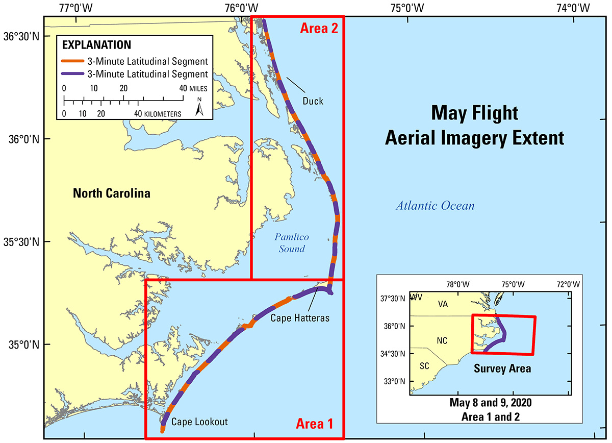
Figure 1. Regional map showing the survey area along the Outer Banks, North Carolina.
Suggested Citation
Kranenburg, C.J., Ritchie, A.C., Brown, J.A., Over, J.R., Sherwood, C.R., Warrick, J.A., and Wernette, P.A., 2022, Aerial imagery of the North Carolina coast: 2020-05-08 to 2020-05-09: U.S. Geological Survey data release, https://doi.org/10.5066/P9OCDOYZ.