In accordance with SO #3423 - The Gulf of America and SO #3424 - Mount McKinley and Landmarks Honoring the Alaskan People, new USGS data releases specific to those named places will utilize the new name Gulf of America and the restored name Mount McKinley. Per USGS practice, historical data will retain the name of the geographic features as they were known at the time the data were originally released.
Data Release
Coastal Bathymetry and Backscatter Data Collected in September and October 2019 from Rockaway Peninsula, New York
By Chelsea A. Stalk, Nancy T. DeWitt, Emily A. Wei, Andrew S. Farmer, Jennifer L. Miselis, and Jake J. Fredericks
USGS, St. Petersburg, Florida
Summary
Scientists from the U.S. Geological Survey St. Petersburg Coastal and Marine Science Center in St. Petersburg, Florida (USGS – SPCSMC), conducted a geophysical survey nearshore the Rockaway Peninsula, New York, during September and October 2019. During this study, multibeam bathymetry and acoustic backscatter data were collected aboard the R/V Sallenger (two separate survey efforts: Leg 1—October 4–6; Leg 2—October 24–29), while single-beam bathymetry data were collected aboard a towed seismic sled and two personal watercraft (PWC) (September 27–October 6). Efforts were supported by the National Fish and Wildlife Foundation (NFWF) Beach and Marsh Monitoring Project and the USGS Coastal Sediment Availability and Flux (CSAF) Project. Both projects aim to assess sediment availability and exchange in nearshore environments and incorporate shoreface morphology and geology into coastal-change assessments and predictions. For further information regarding data collection and/or processing methods refer to the associated metadata.
Data
| File Name and Description | Metadata (XML format) | Metadata (text format) | Download File |
|---|---|---|---|
| Rockaway_2019_SBES_xyz.zip Single-beam bathymetry xyz data in both WGS84 (G1762) ellipsoid and NAD83 NAVD88 GEOID12B (.txt) |
Rockaway_2019_SBES_ metadata.xml |
Rockaway_2019_SBES_ metadata.txt |
Rockaway_2019_SBES_xyz.zip (48.1 MB) |
| Rockaway_2019_SBES_Tracklines.zip Single-beam bathymetry tracklines in WGS84 (G1762) (.shp) |
Same as above | Same as above | Rockaway_2019_SBES_Tracklines.zip (11.6 MB) |
| Rockaway_2019_MBES_Leg1_xyz.zip Processed elevation point data (xyz) as derived from a 1-meter grid provided in both WGS84 (G1762) ellipsoid and NAD83 NAVD88 GEOID12B (.xyz) |
Rockaway_2019_MBES_ Leg1_metadata.xml |
Rockaway_2019_MBES_ Leg1_metadata.txt |
Rockaway_2019_MBES_Leg1_xyz.zip (29.3 MB) |
| Rockaway_2019_MBES_Leg1_Backscatter.zip Processed acoustic intensity backscatter mosaic, derived from the 1-meter grid, provided as an 8-point GeoTIFF in WGS84 (G1762) ellipsoid (.tif) |
Same as above | Same as above | Rockaway_2019_MBES_Leg1_Backscatter.zip (12.5 MB) |
| Rockaway_2019_MBES_Leg2_xyz.zip Processed elevation point data (xyz) as derived from a 1-meter grid provided in WGS84 (G1762) ellipsoid and NAD83 NAVD88 GEOID12B (.xyz) |
Rockaway_2019_MBES_ Leg2_metadata.xml |
Rockaway_2019_MBES_ Leg2_metadata.txt |
Rockaway_2019_MBES_Leg2_xyz.zip (261.4 MB) |
Rockaway_2019_MBES_Leg2_Backscatter.zip |
Same as above | Same as above | Rockaway_2019_MBES_Leg2_Backscatter.zip (106.6 MB) |
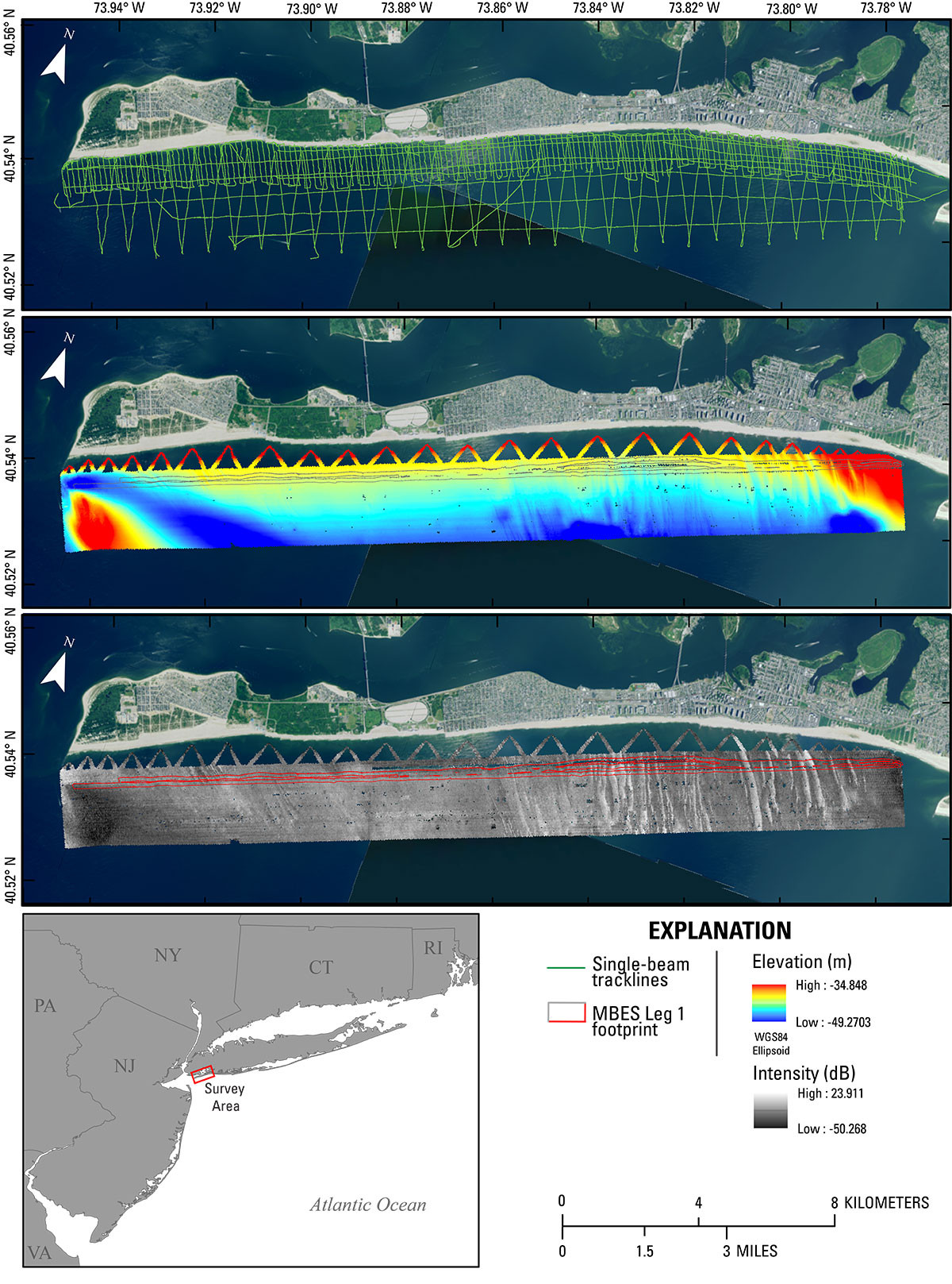
Figure 1. Location map for the 2019 Rockaway Peninsula, New York, survey which incorporates single-beam bathymetry (top), multibeam bathymetry (middle) and associated backscatter (bottom). Multibeam echosounder (MBES) data acquired on survey leg 1 are demonstrated by a footprint outlined in grey and red. Multibeam bathymetry and backscatter data are represented by a 1-meter digital elevation model in WGS84 (G1762) ellipsoid height. Background image obtained from 2017 National Agricultural Image Program (NAIP). These data should not be used for navigational purposes.
Suggested Citation
Stalk, C.A., DeWitt, N.T., Wei, E.A., Farmer, A.S., Miselis, J.L., and Fredericks, J.J., 2020, Coastal bathymetry and backscatter data collected in September and October 2019 from Rockaway Peninsula, New York: U.S. Geological Survey data release, https://doi.org/10.5066/P9WNJSFN.