In accordance with SO #3423 - The Gulf of America and SO #3424 - Mount McKinley and Landmarks Honoring the Alaskan People, new USGS data releases specific to those named places will utilize the new name Gulf of America and the restored name Mount McKinley. Per USGS practice, historical data will retain the name of the geographic features as they were known at the time the data were originally released.
Data Release
Single-Beam Bathymetry Data Collected in 2015 Nearshore Dauphin Island, Alabama
By Nancy T. DeWitt,1 Chelsea A. Stalk,2 James G. Flocks,1 Julie C. Bernier,1 Kyle W. Kelso,1 Jake J. Fredericks,1 and Thomas Tuten2
1U.S. Geological Survey
2Cherokee Nation Technologies
Summary
Dauphin Island, Alabama is a barrier island located in the Northern Gulf of Mexico that supports local residences, tourism, commercial infrastructure, and the historical Fort Gaines. During the past decade, Dauphin Island has been impacted by several major hurricanes (Ivan, 2004; Katrina, 2005; Isaac, 2012). Storms, along with sea level rise, present a continued threat to island stability. State and federal managers are taking a scientific, investigative approach to identify the best options available to formulate and implement a long-term plan to properly restore Dauphin Island and provide resilience against future storms and sea-level rise. Island morphology, including current bathymetry and shoreline data, is one of several aspects being investigated and funded through a grant from the National Fish and Wildlife Foundation Gulf Environmental Benefit Fund. In 2015, the United States Geological Survey Saint Petersburg Coastal and Marine Science Center (USGS SPCMSC), in cooperation with the United States Army Corps of Engineers (USACE) and the state of Alabama, conducted bathymetric surveys of the nearshore waters surrounding Dauphin Island. This data release provides 1,165-line kilometers (km) of processed single-beam bathymetry (SBB) data collected by the USGS SPCMSC in August 2015 (Field Activity Number [FAN] 2015-326-FA). Data were acquired aboard four separate survey vessels; the RV Sallenger (subFAN, 15BIM10), the RV Jabba Jaw (subFAN, 15BIM11), the RV Shark (subFAN, 15BIM12), and the RV Chum (subFAN, 15BIM13). The data are provided in three datums: 1) the International Terrestrial Reference Frame of 2000 (ITRF00), ellipsoid height (-47.04 meters [m] to -29.36 m); 2) the North American Datum of 1983, realization of CORS96 (NAD83 [CORS96]) horizontal, and the North American Vertical Datum 1988 (NAVD88) vertical (-0.24 m to -17.33 m); and 3) the NAD83 (CORS96) horizontal, and Mean Lower Low Water (MLLW) vertical (-0.12 m to -17.93 m). Additional files include trackline shapefiles, digital and handwritten Field Activity Collection Systems (FACS) logs, a comprehensive 50-meter Digital Elevation Model (DEM), and formal Federal Geographic Data Committee (FGDC) metadata.
Data
| File Name and Description | Metadata (XML format) | Metadata (text format) | Download File |
|---|---|---|---|
| Dauphin_Island_2015_SBB_ITRF00_ xyz.zip The single-beam soundings (xyz) in ITRF00 and ellipsoid height (.txt) |
Dauphin_Island_2015_SBB_ ITRF00_xyz_metadata.xml |
Dauphin_Island_2015_SBB_ ITRF00_xyz_metadata.txt |
Dauphin_Island_2015_SBB_ ITRF00_xyz.zip (102.1 MB) |
| Dauphin_Island_2015_SBB_ITRF00_ 50_DEM.zip Bathymetry DEM, 50-m cell size in ITRF00 (.tif) |
Same as above | Same as above | Dauphin_Island_2015_SBB_ ITRF00_50_DEM.zip (174 KB) |
| Dauphin_Island_2015_SBB_ITRF00_ tracklines.zip Single-beam trackline shapefile in ITRF00 (.shp) |
Same as above | Same as above | Dauphin_Island_2015_SBB_ ITRF00_tracklines.zip (53.7 MB) |
| Dauphin_Island_2015_SBB_ NAD83_ NAVD88_GEOID12A _xyz.zip The single-beam soundings (xyz) in NAD83 and NAVD88 (orthometric height) with respect to the GEOID12A model (.txt) |
Dauphin_Island_2015_SBB_NAD83_NAVD88_ GEOID12A_MLLW_xyz_metadata.xml |
Dauphin_Island_2015_SBB_NAD83_NAVD88_ GEOID12A_MLLW_xyz_metadata.txt |
Dauphin_Island_2015_SBB_NAD83_ NAVD88_GEOID12A_xyz.zip (117.4 MB) |
| Dauphin_Island_2015_SBB_NAD83_ NAVD88_GEOID12A_50_DEM.zip Bathymetry DEM, 50-m cell size, in NAD83 and NAVD88 with respect to the GEOID12A model (.tif) |
Same as above | Same as above | Dauphin_Island_2015_SBB_NAD83_ NAVD88_GEOID12A_50_DEM.zip (180 KB) |
| Dauphin_Island_2015_SBB_NAD83_ tracklines.zip Single-beam trackline shapefile in NAD83 (.shp) |
Same as above | Same as above | Dauphin_Island_2015_SBB_ NAD83_tracklines.zip (58.8 MB) |
| Dauphin_Island_2015_SBB_NAD83_ MLLW_xyz.zip The single-beam soundings (xyz) in NAD83 MLLW (.txt) |
Same as above | Same as above | Dauphin_Island_2015_SBB_ NAD83_MLLW_xyz.zip (117.5 MB) |
| Dauphin_Island_2015_SBB_NAD83_ MLLW_50_DEM.zip Bathymetry DEM, 50-m cell size, in NAD83 and MLLW (.tif) |
Same as above | Same as above | Dauphin_Island_2015_SBB_ NAD83_MLLW_50_DEM.zip (179 KB) |
| Supplemental information | |||
| 2015-326-FA_FACS.zip Field Activity Collections System (FACS) for USGS FAN 2015-326-FA. Includes overview and crew logs (.pdf) |
Not applicable | Not applicable | 2015-326-FA_FACS.zip (24 KB) |
| 15BIM10_FACS_Operations.zip FACS for USGS subFAN 15BIM10. Includes GPS equipment andvessel offsets, and handwritten operation notes (.docx) |
Not applicable | Not applicable | 15BIM10_FACS_Operations.zip (66 KB) |
| 15BIM11_FACS_Operations.zip FACS for USGS subFAN 15BIM11. Includes GPS equipment andvessel offsets, and handwritten operation notes (.docx) |
Not applicable | Not applicable | 15BIM11_FACS_Operations.zip (3.3 MB) |
| 15BIM12_FACS_Operations.zip FACS for USGS subFAN 15BIM12. Includes GPS equipment andvessel offsets, and handwritten operation notes (.docx) |
Not applicable | Not applicable | 15BIM12_FACS_Operations.zip (76 MB) |
| 15BIM13_FACS_Operations.zip FACS for USGS subFAN 15BIM13. Includes GPS equipment andvessel offsets, and handwritten operation notes (.docx) |
Not applicable | Not applicable | 15BIM13_FACS_Operations.zip (76 MB) |
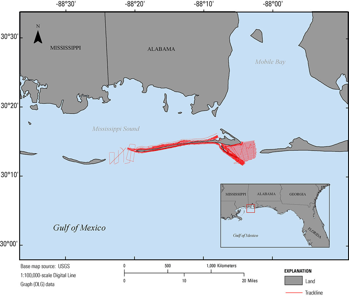
Figure 1. Map showing the 2015 single-beam bathymetry tracklines (red) nearshore Dauphin Island, Alabama. Base map is USGS 1:100,000-scale Digital Line Graph (DLG) data.
Suggested Citation
DeWitt, N.T., Stalk, C.A., Flocks, J.G., Bernier, J.C., Kelso, K.W., Fredericks, J.J., and Tuten, T., 2017, Single-beam bathymetry data collected in 2015 nearshore Dauphin Island, Alabama: U.S. Geological Survey data release, https://doi.org/10.5066/F7BZ648W.