In accordance with SO #3423 - The Gulf of America and SO #3424 - Mount McKinley and Landmarks Honoring the Alaskan People, new USGS data releases specific to those named places will utilize the new name Gulf of America and the restored name Mount McKinley. Per USGS practice, historical data will retain the name of the geographic features as they were known at the time the data were originally released.
Data Release
Archive of Sediment Data from Vibracores Collected in 2016 from Fire Island, New York
By Julie C. Bernier,1 Noreen A. Buster,1 Owen T. Brenner,1 Kyle W. Kelso,1 Thomas M. Tuten,2 and Jennifer L. Miselis1
1U.S. Geological Survey
2Cherokee Nation Technologies
Summary
Researchers from the U.S. Geological Survey (USGS) conducted a long-term coastal morphologic-change study at Fire Island, New York, prior to and after Hurricane Sandy impacted the area in October 2012. The Fire Island Coastal Change project objectives include understanding the morphologic evolution of the barrier island system on a variety of time scales (months to centuries) and resolving storm-related impacts, post-storm beach response, and recovery. In April 2016, scientists from the USGS St. Petersburg Coastal and Marine Science Center conducted sediment sampling and geophysical surveys on Fire Island to characterize and quantify spatial variability in the subaerial geology with the goal of subsequently integrating onshore geology with other surf zone and nearshore datasets.
This data release serves as an archive of sediment data from 14 vibracores collected along 6 profiles from the upper beach to shoreface along Fire Island on April 10 and 11, 2016 (USGS Field Activity Number [FAN] 2016–322–FA). Sedimentologic and stratigraphic metrics (for example, sediment texture or unit thicknesses) derived from these data can be used to assess spatial and temporal trends and may aid in understanding beach evolution. Data collection and processing methods are described in U.S. Geological Survey Data Series 1100.
Data
| File Name and Description | Metadata (XML format) | Metadata (text format) | Download File |
|---|---|---|---|
| 2016-322-FA_CoreSites.zip Sample locations (.xlsx, .csv, .shp, .kml) |
2016-322-FA_sediment-met.xml | 2016-322-FA_sediment-met.txt | 2016-322-FA_CoreSites.zip (42 KB) |
| 2016-322-FA_CoreLogs.zip Core logs with grain-size plots (.jpg) |
Same as above | Same as above | 2016-322-FA_CoreLogs.zip (17.9 MB) |
| 2016-322-FA_CorePhotos.zip Core photographs (.jpg) |
Same as above | Same as above | 2016-322-FA_CorePhotos.zip (18.7 MB) |
| 2016-322-FA_GrainSize_SumStats.zip Grain-size summary statistics (.xlsx, .csv) |
Same as above | Same as above | 2016-322-FA_GrainSize_SumStats.zip (692 KB) |
| Supplemental information | |||
| 2016-322-FA_FACS.zip Field Activity Collection System (FACS) logs (.docx) |
Not applicable | Not applicable | 2016-322-FA_FACS.zip (13 KB) |
| 2016-322-FA_GrainSize_RunStats.zip GRADISTAT grain-size run statistics (.xlsx) |
Not applicable | Not applicable | 2016-322-FA_GrainSize_RunStats.zip (6.8 MB) |
| 2016-322-FA_ProfElev_to_CoreDepth.zip Table showing elevations and sediment depths of previously-surveyed beach surfaces at each core site (.docx) |
Not applicable | Not applicable | 2016-322-FA_ProfElev_to_CoreDepth.zip (32 KB) |
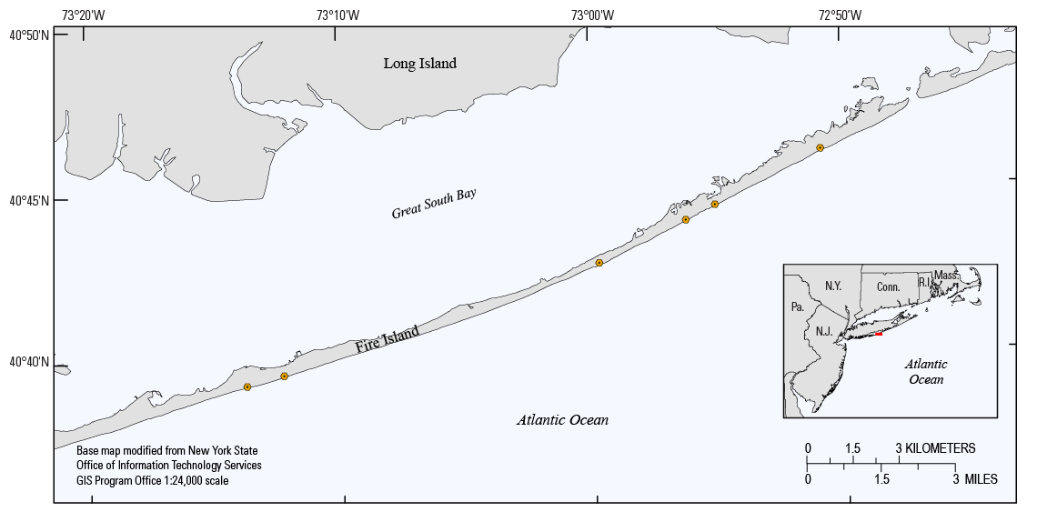
Figure 1. Locations of sites where vibracores (orange circles) were collected along previously surveyed beach-elevation profiles in April 2016 (Field Activity Number [FAN] 2016-322–FA).
Suggested Citation
Bernier, J.C., Buster, N.A., Brenner, O.T., Kelso, K.W., Tuten, T.M., and Miselis, J.L., 2018, Archive of sediment data from vibracores collected in 2016 from Fire Island, New York: U.S. Geological Survey data release, https://doi.org/10.5066/F7FN15GX.