In accordance with SO #3423 - The Gulf of America and SO #3424 - Mount McKinley and Landmarks Honoring the Alaskan People, new USGS data releases specific to those named places will utilize the new name Gulf of America and the restored name Mount McKinley. Per USGS practice, historical data will retain the name of the geographic features as they were known at the time the data were originally released.
Data Release
Single-beam Bathymetry Data Collected in 2022 From Point Aux Chenes Bay, Mississippi
By Nancy T. DeWitt, Benjamin A. Galbraith, Joseph F. Terrano, Christopher G. Smith, Kathryn E.L. Smith, and Chelsea A. Stalk
U.S. Geological Survey, St. Petersburg Coastal and Marine Science Center
Summary
Scientists from the U.S. Geological Survey St. Petersburg Coastal and Marine Science Center (USGS – SPCSMC), conducted a single-beam bathymetry survey within Point Aux Chenes Bay, Mississippi, in June 2022 under the USGS Field Activity Number (FAN) 2022-320-FA. The data was collected from two personal watercrafts (PWC): RV Shark (SubFAN 22CCT09, WVR1) and RV Chum (SubFAN 22CCT10, WVR2). A resurvey of just the north and south subtidal reefs occurred in November 2022 (SubFANs 22CCT11 and 22CCT12 respectively). Efforts were supported by the Coastal Marine Hazards Research Program (CMHRP) and the National Oceanic and Atmospheric Association (NOAA) Effects of Sea Level Rise (ESLR) Program in partnership with Grand Bay National Estuarine Research Reserve and Mississippi State University. The processed point data files (xyz) are released in two horizontal datums, the Word Geodetic System of 1984 (WGS84, G2139) ellipsoid height, and the North American Datum of 1983 (NAD83 2011). The data are also referenced to the North American Vertical Datum of 1988 (NAVD88) orthometric height with respect to GEOID12A. Additional data products include a single-beam trackline shapefile, a 10-meter(m) cell-size Digital Elevation Model (DEM), and formal Federal Geographic Data Committee (FGDC) metadata. Methods from Terrano and others (2021) were used to derive the 2022 shoreline. Methods from Stalk and others (2021) were utilized to create the 2022 DEM. For further information regarding data collection and/or processing methods, refer to the associated metadata.
Stalk, C.S., Wilcox, H.S., Passeri, D.L., Smith, C.G., Smith, K.E.L., and Terrano, J.F., 2021, Single-beam bathymetry data collected in March 2021 from Grand Bay and Point Aux Chenes Bay, Mississippi/Alabama: U.S. Geological Survey data release, https://doi.org/10.5066/P93ZM9MK.
Terrano, J.F., Smith, K.E.L., Pitchford, J.L., Archer, M., and Brochard, M., 2021, Shorelines from high-resolution WorldView satellite imagery, real-time kinematic global positioning data, and aerial imagery for 2013 to 2020 for study sites within Grand Bay National Estuarine Research Reserve, Mississippi: U.S. Geological Survey data release, https://doi.org/10.5066/P9W8TNQM.
Data
| File Name and Description | Metadata (XML format) | Metadata (text format) | Download File |
|---|---|---|---|
| Point_Aux_Chenes_2022_ SBES_xyz.zip Single-beam bathymetry xyz data in both WGS84 (G2139) ellipsoid and NAD83 NAVD88 GEOID12A (.txt) and data dictionary (.docx) |
Point_Aux_Chenes_2022_ SBES_xyz_metadata.xml |
Point_Aux_Chenes_2022_ SBES_xyz_metadata.txt |
Point_Aux_Chenes_2022_ SBES_xyz.zip (112 MB) |
| Point_Aux_Chenes_2022_ SBES_Tracklines.zip Single-beam bathymetry tracklines in WGS84 (G2139) (.shp) and data dictionary (.docx) |
Same as above | Same as above | Point_Aux_Chenes_2022_ SBES_tracklines.zip (28.9 MB) |
| Point_Aux_Chenes_2022_ SBES_NAD83_NAVD88_GEOID12A_ UTM16N_10m_DEM.zip Single-beam bathymetry DEM, 10-m cell size in NAD83 NAVD88 GEOID 12A and the accompanying boundary shapefile (.tif, shp) |
Same as above | Same as above | Point_Aux_Chenes_2022_ SBES_NAD83_NAVD88_GEOID12A_ UTM16N_10m_DEM.zip (1.5 MB) |
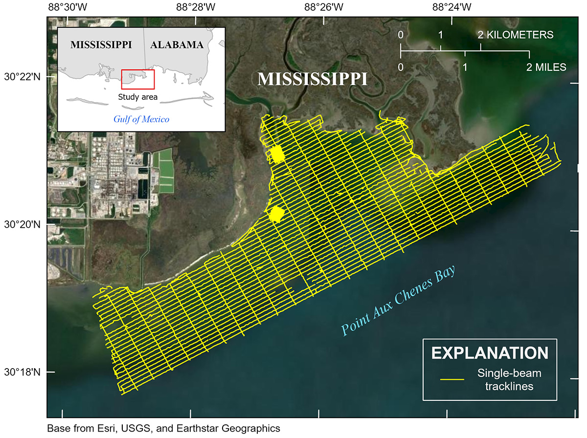
Figure 1. Map of Point Aux Chenes Bay, Mississippi, showing single-beam bathymetry data collection tracklines in yellow.
Suggested Citation
DeWitt, N.T., Galbraith, B.A., Terrano, J.F., Smith, K.E.L., and Stalk, C.A., 2024, Single-beam bathymetry data collected in 2022 from Point Aux Chenes, Mississippi: U.S. Geological Survey data release, https://doi.org/10.5066/P13NPYMZ.