
In accordance with SO #3423 - The Gulf of America and SO #3424 - Mount McKinley and Landmarks Honoring the Alaskan People, new USGS data releases specific to those named places will utilize the new name Gulf of America and the restored name Mount McKinley. Per USGS practice, historical data will retain the name of the geographic features as they were known at the time the data were originally released.
Data Release
Sediment Data from Vibracores Collected in 2021 From Central Florida Gulf Coast Barrier Islands
By Julie C. Bernier, Cheyenne S. Everhart, Daniel J. Ciarletta, Nancy T. DeWitt, and Jennifer L. Miselis
U.S. Geological Survey, St. Petersburg Coastal and Marine Science Center
Summary
In 2021, scientists from the U.S. Geological Survey St. Petersburg Coastal and Marine Science Center (USGS SPCMSC) conducted ground penetrating radar (GPR) and sediment sampling surveys on barrier islands located along the central Florida Gulf Coast (CFGC), Pinellas County, Florida. This study investigated the past evolution of the CFGC from field sites at Anclote Keys, Caladesi and Honeymoon Islands, and Fort DeSoto to quantify changes that occurred along these barrier systems prior to the 20th century.
This data release serves as an archive of sedimentologic data from vibracores collected from back-barrier environments at Dutchman Key, Anclote Key, Caladesi Island, Honeymoon Island, Cabbage Key, Mullet Key, and St. Jean Key study sites on February 19 and May 11-13, 2021 (USGS Field Activity Number 2021-308-FA). GPR data collected during the same survey are available as a separate data release (Forde and others, 2023). Sedimentologic data from these cores, including descriptive core logs and grain-size data, are provided to characterize and date shallow subsurface stratigraphic units including beach, dune, and washover deposits. Samples selected for Optically Stimulated Luminescence (OSL) dating were analyzed at the USGS Luminescence Dating Laboratory (Denver, Colorado); those results will be made available as a separate data release. These data were targeted according to the methods outlined by Ciarletta and others (2023), with sediment cores positioned to investigate interpretations of barrier-island evolution from surface morphology. Acquisition of sediment cores and analyses of core lithology and grain size follow the methods of Buster and others (2018), with modifications for high-resolution photography after Ciarletta and others (2023).
Buster, N.A., Bernier, J.C., Brenner, O.T., Kelso, K.W., Tuten, T.M., and Miselis, J.L., 2018, Sediment data from vibracores collected in 2016 from Fire Island, New York: U.S. Geological Survey Data Series 1100, https://doi.org/10.3133/ds1100.
Ciarletta, D.J., Miselis, J.L., Bernier, J.C., Forde, A.S., and Mahan, S., 2023, Reconstructing the geomorphic evolution and sediment budget history of a dynamic barrier island: Anclote Key, Florida, in Wang, P., Royer, E., and Rosati, J.D., (eds.), Proceedings of the Coastal Sediments 2023, New Orleans, Louisiana, April 11-15, 2023: World Scientific Publishing, p. 1-11, https://doi.org/10.1142/9789811275135_0001.
Forde, A.S., Bernier, J.C., and Ciarletta, D.J., 2023, Ground penetrating radar and Global Positioning System data collected in 2021 from Pinellas barrier islands, Florida: U.S. Geological Survey data release, https://doi.org/10.5066/P9NV5NAP.
Data
| File Name and Description | Metadata (XML format) | Metadata (text format) | Download File |
|---|---|---|---|
| 2021-308-FA_CoreSites.zip Site location information and core parameters for 2021-308-FA vibracores (.xlsx, .csv, .shp, .kml) |
2021-308-FA_Sediment_metadata.xml | 2021-308-FA_Sediment_metadata.txt | 2021-308-FA_CoreSites.zip (44 KB) |
| 2021-308-FA_CoreLogs.zip Descriptive core logs for 2021-308-FA vibracores (.jpg) |
Same as above | Same as above | 2021-308-FA_CoreLogs.zip (8.5 MB) |
| 2021-308-FA_CorePhotos.zip High-resolution photographs for 2021-308-FA vibracores (.jpg) |
Same as above | Same as above | 2021-308-FA_CorePhotos.zip (473.5 MB) |
| 2021-308-FA_GrainSizeData.zip Grain-size data including raw data, summary statistics, and summary plots for 2021-308-FA vibracore samples (.xlsx, .csv, .jpg) |
Same as above | Same as above | 2021-308-FA_GrainSizeData.zip (2.3 MB) |
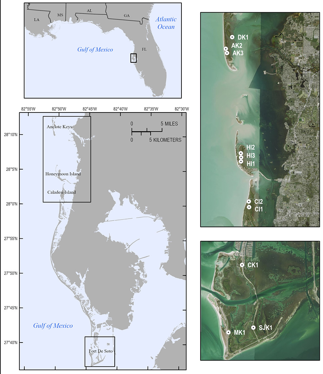
Figure 1. Regional map [top left] showing the 2021 Central Florida Gulf Coast (CFCG), Florida, study area [bottom left]. Inset maps show [top right] Dutchman Key (DK), Anclote Key (AK), Honeymoon Island (HI), and Caladesi Island (CI) and [bottom right] Cabbage Key (CK), St. Jean Key (SJK), and Mullet Key (MK) vibracore locations overlaid with 2021 National Agriculture Imagery Program (NAIP) aerial imagery basemap.
Suggested Citation
Bernier, J.C., Everhart, C.S., DeWitt, N.T., Ciarletta, D.C., and Miselis, J.L., 2024, Sediment data from vibracores collected in 2021 from central Florida Gulf Coast barrier islands: U.S. Geological Survey data release, https://doi.org/10.5066/P14L5SVG.