In accordance with SO #3423 - The Gulf of America and SO #3424 - Mount McKinley and Landmarks Honoring the Alaskan People, new USGS data releases specific to those named places will utilize the new name Gulf of America and the restored name Mount McKinley. Per USGS practice, historical data will retain the name of the geographic features as they were known at the time the data were originally released.
Data Release
Coastal Bathymetry Data Collected in 2016 nearshore from West Ship Island to Horn Island, Gulf Islands National Seashore, Mississippi
By Nancy T. DeWitt,1 Chelsea A. Stalk,2 Jake J. Fredericks,1 James G. Flocks,1 Kyle W. Kelso,1 Andrew S. Farmer,2 Thomas M. Tuten,2 and Noreen A. Buster1
1U.S. Geological Survey
2Cherokee Nation Technologies
Summary
The U.S. Geological Survey St. Petersburg Coastal and Marine Science Center (USGS SPCMSC), in cooperation with the US Army Corps of Engineers (USACE) conducted bathymetric surveys of the nearshore waters surrounding Ship and Horn Islands, Gulf Islands National Seashore, Mississippi (GUIS). Camille Cut separates Ship Island into East Ship Island and West Ship Island. The objective of this study was to establish base-level elevation conditions around West Ship Island, East Ship Island, Horn Island and their associated active littoral system prior to restoration activities. These activities include the closure of Camille Cut and the placement of sediment in the littoral zone of West Ship Island. This survey will be used to verify sediment migration patterns by monitoring elevation change over time. The dataset produced by this survey will also be used to measure against historic bathymetric datasets to further understand island elevation over time.
This data release provides 667-line kilometers (km) of processed single-beam bathymetry (SBB) data and 773-line km of processed Interferometric Bathymetry (IFB) collected by the USGS SPCMSC in July 2016 (field activity number [FAN] 2016-347-FA). The IFB were acquired on board the Research Vessel (R/V) Sallenger (subFAN, 16BIM04), and the SBB was acquired on board the R/V Jabba Jaw (subFAN, 16BIM05) and the R/V Mako (subFAN, 16BIM06). The IFB and SBB point data are provided in three datums: 1) the International Terrestrial Reference Frame of 2000 (ITRF00), ellipsoid height (-49.70 meters [m] to -28.87 m); 2) the North American Datum of 1983 (NAD83) CORS96 realization and the North American Vertical Datum 1988 (NAVD88) with respect to the GEOID12B model (-0.07 m to -20.69 m); and 3) NAD83 (CORS96) and Mean Lower Low Water (MLLW) (-0.04 m to -20.60 m). A comprehensive 50-meter Digital Elevation Model (DEM) created from the IFB and SBB point data is provided in NAD83 NAVD88 GEOID12B.Additional files include trackline shapefiles, respective digital and handwritten field logs, and formal Federal Geographic Data Committee (FGDC) metadata. For further information regarding data collection and processing please refer to the metadata.
Data
| File Name and Description | Metadata (XML format) | Metadata (text format) | Download File |
|---|---|---|---|
| Ship_Horn_Island_2016_IFB_SBB_ NAD83_NAVD88_GEOID12B_50_DEM.zip Bathymetry DEM, 50-m cell size, in NAD83 and NAVD88 with respect to the GEOID12B model (.tif) |
Ship_Horn_Island_2016_IFB_SBB_ DEM_metadata.xml |
Ship_Horn_Island_2016_IFB_SBB_ DEM_metadata.txt |
Ship_Horn_Island_2016_IFB_SBB_ NAD83_NAVD88_GEOID12B_50_DEM.zip (0.39 MB) |
| Ship_Horn_Island_2016_IFB_ ITRF00_5m_xyz.zip Interferometric bathymetry soundings (xyz) in ITRF00 and ellipsoid height (.txt) |
Ship_Horn_Island_2016_IFB_ xyz_metadata.xml |
Ship_Horn_Island_2016_IFB_ xyz_metadata.txt |
Ship_Horn_Island_2016_IFB_ ITRF00_5m_xyz.zip (7 MB) |
| Ship_Horn_Island_2016_IFB_ ITRF00_tracklines.zip Interferometric bathymetry trackline shapefile in ITRF00 (.shp) |
Same as above | Same as above | Ship_Horn_Island_2016_IFB_ ITRF00_tracklines.zip (31 MB) |
| Ship_Horn_Island_2016_IFB_ NAD83_NAVD88_GEOID12B_5m_xyz.zip Interferometric bathymetry soundings (xyz) in NAD83 and NAVD88 (orthometric height) with respect to the GEOID12B model (.txt) |
Same as above | Same as above | Ship_Horn_Island_2016_IFB_ NAD83_NAVD88_GEOID12B_5m_xyz.zip (18 MB) |
| Ship_Horn_Island_2016_IFB_ NAD83_MLLW_5m_xyz.zip Interferometric bathymetry soundings (xyz) in NAD83 and MLLW (.txt) |
Same as above | Same as above | Ship_Horn_Island_2016_IFB_ NAD83_MLLW_5m_xyz.zip (15 MB) |
| Ship_Horn_Island_2016_IFB_ NAD83_tracklines.zip Interferometric bathymetry trackline shapefile in NAD83 (.shp) |
Same as above | Same as above | Ship_Horn_Island_2016_IFB_ NAD83_tracklines.zip (32 MB) |
| Ship_Horn_Island_2016_SBB_ ITRF00_xyz.zip Single-beam soundings (xyz) in ITRF00 and ellipsoid height (.txt) |
Ship_Horn_Island_2016_SBB xyz_metadata.xml | Ship_Horn_Island_2016_SBB_ xyz_metadata.txt |
Ship_Horn_Island_2016_SBB_ ITRF00_xyz.zip (28 MB) |
| Ship_Horn_Island_2016_SBB_ ITRF00_tracklines.zip Single-beam trackline shapefile in ITRF00 (.shp) |
Same as above | Same as above | Ship_Horn_Island_2016_SBB_ ITRF00_tracklines.zip (29 MB) |
| Ship_Horn_Island_2016_SBB_ NAD83_NAVD88_GEOID12B_xyz.zip Single-beam soundings in (xyz) in NAD83 and NAVD88 (orthometric height) with respect to the GEOID12B model (.txt) |
Same as above | Same as above | Ship_Horn_Island_2016_SBB_ NAD83_NAVD88_GEOID12B_xyz.zip (49 MB) |
| Ship_Horn_Island_2016_SBB_ NAD83_MLLW_xyz.zip Single-beam soundings (xyz) in NAD83 and MLLW (.txt) |
Same as above | Same as above | Ship_Horn_Island_2016_SBB_ NAD83_MLLW_xyz.zip (49 MB) |
| Ship_Horn_Island_2016_SBB_ NAD83_tracklines.zip Single-beam bathymetry trackline shapefile in NAD83 (.shp) |
Same as above | Same as above | Ship_Horn_Island_2016_SBB_ NAD83_tracklines.zip (29 MB) |
| Supplemental Information | |||
| 2016-347-FA_FACS.zip Field Activity Collections System (FACS) for USGS FAN 2016-347-FA. Includes overview and crew logs (.docx) |
Not applicable | Not applicable | 2016-347-FA_FACS.zip (25 KB) |
| 16BIM04_FACS_Operations.zip FACS for USGS subFAN 16BIM04. Includes survey equipment and vessel offsets (.docx) |
Not applicable | Not applicable | 16BIM04_FACS_Operations.zip (60 KB) |
| 16BIM05_FACS_Operations.zip FACS for USGS subFAN 16BIM05. Includes survey equipment and vessel offsets, (.docx) |
Not applicable | Not applicable | 16BIM05_FACS_Operations.zip (921 KB) |
| 16BIM06_FACS_Operations.zip FACS for USGS subFAN 16BIM06. Includes survey equipment, vessel offsets, and handwritten operation notes (.docx) |
Not applicable | Not applicable | 16BIM06_FACS_Operations.zip (832 KB) |
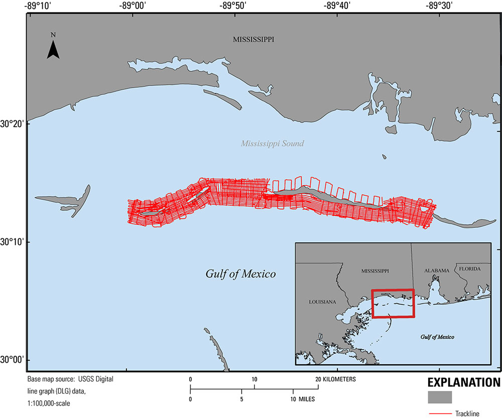
Figure 1. Map showing the 2016 interferometric swath and single-beam bathymetry tracklines (red) nearshore Ship and Horn Islands, Gulf Islands National Seashore, Mississippi. Base map is USGS 1:100,000-scale Digital Line Graph (DLG) data.
Suggested Citation
DeWitt, N.T., Stalk, C.A., Fredericks, J.J., Flocks, J.G., Kelso, K.W., Farmer, A.S., Tuten, T.M., and Buster, N.A., 2017, Coastal bathymetry data collected in 2016 nearshore from West Ship Island to Horn Island, Gulf Islands National Seashore, Mississippi: U.S. Geological Survey data release,https://doi.org/10.5066/F7B8571Q.